Places, Earth
Sierra Highway
Sierra Highway
|
|
Places, Earth
Sierra Highway |
|
| Once a major route northeast out of Los Angeles, today Sierra Highway handles mostly local traffic roughly parallel to Highway 14 between the Newhall Pass and Mojave. A major railroad line also roughly parallels the route to Mojave. A section was used in the movie Duel. |
 Looking west along San Fernando Raod toward Sierra Highway. |
 Looking north from the south end of Sierra Highway. |
| We begin our adventure at the intersection of San Fernando Road, Old Road, and Sierra Highway beside the Interstate 5 and Highway 14 interchange and near the railroad. A few feet and we pass over the railroad and under the Interstate 5 Truck Route. To the right is the end of Foothill Boulevard. A few hundred feet more and we pass under Highway 14. A mile or so later we pass the location of Beale’s Cut, once an important route through the pass, today somewhere off to the side and not visible from the highway. Somewhere |
 What looks like a former gas station. |
 Beale's Cut once connected the San Fernando Valley to Newhall. |
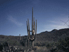
below, a train tunnel connects the San Fernando Valley to Newhall and the Santa Crarita Valley, once one of the longest railroad tunnels in the country. We pass Eternal Valley Cemetery, watch the road on this drive or you may end up here. Next we emerge into the east edge of Santa Clarita Valley and continue north crossing Newhall Avenue with William S. Hart Park and Museum a few miles west and then Placerita Canyon Road with The Golden Oaks Ranch and Placerita Nature Center a short distance east. There is still only a little development before we then begin passing an oil field. |
| After about four miles of no or light development, suddenly there are homes and businesses as we cross Golden Valley Road (5 miles) and Via Princessa. The highway passes over the Santa Clara River (7 miles) and crosses Soledad Canyon Road. After a mile or two we pass College of the Canyons to the east. |
|
After about 8 miles Santa Clarita is passing behind as development slowly fades out. By Sand
Canyon Road at 10 miles development is fading and by Vasquez Canyon Road (10 miles), development has ended. I note the Halfway House Café on the east side (15564 Sierra Highway; Santa Clarita) (12 miles). We are roughly parallel to the river, the railroad, and Highway 14 running northeast, all to the southeast of us. A coyote runs across the road. The highway curves between low hills and road cuts. |
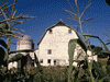
 Halfway House Café. |
| A sign says “Welcome to Agua Dulce.” I stop to photograph a bit of what might be called folk art (14 miles) on the west side of the highway and a short distance later I note the turnoff to Rowher Flat Off Highway Vehicle Area to the west (14 miles). The off road area was “Closed | |
 Odd collection of objects and furniture beside Sierra Highway. |
 Turn off to Rowher Flat Off Highway Vehicle Area. |
| due to fire danger.” A few minutes later we pass through the small settlements of Sleepy Valley and The Oaks at about 15.5 miles. I wondered what I would find along Mint Canyon Road (17 and again a mile and a half later). We cross Auga Dulce Canyon Road (mile 18), I note a sign, 3 miles to Vasquez Rocks Natural Area Park, about half way between here and Highway 14. Located at 10700 Escondido Canyon Rd, Agua Dulce, CA 91350, this has been used as a filming location for countless projects. We continue on past wine tasting at Ague Dulce Winery (9640 Sierra Highway; Agua Dulce). | |
| As I approached Acton, I noted a curious looking pile to the south, a large bell and a large statue on its back. There are a lot of film ranches in the area. Maybe? Another sign, “Welcome to Acton.” Near Acton we again approach Highway 14 with the railroad still another mile or so beyond. It takes a hard left turn to stay on Sierra Highway, otherwise we would end up on Highway 14. After several miles paralleling Highway 14 on the left side, we cross to the right side with the railroad a short distance still to our right. I have long |
 A statue lying on its back and a bell beside the highway. |
| noticed a collection of old railroad cabooses on the southeast of Highway 14. I assume they are associated with Vincent Hill Station Restaurant and Saloon (553 Sierra Hwy, Acton, CA 93510) in the small settlement of Vincent (mile 32), with the nearby Vincent Grade/Acton Metrolink Station. The railroad cars are fenced off but easy to see from outside. The restaurant was not yet open so I added it to a future list. | |
 Vincent Hill Station and Saloon. |
 Cabooses at Vincent Hill Station and Saloon. |
| As we approach Antelope Valley, we diverge from Highway 14 but the railroad is still close tothe right. It requires a left turn to stay on Sierra Highway or else you will end up in Pearblossom.The highway and railroad pass over the California Aqueduct at the Soledad Siphon (not visiblefrom the highway) then the highway crosses the railroad. We pass on the east side of LakePalmdale, a reservoir along the south side of the San Andrea Fault, but the railroad blocks theview. We cross the fault, but there is no indication. We are now on |
 A single wind turbine on the north shore of Palmdale Lake. |
|
the North American Plate. We see a single wind turbine on the north side of the lake, to the west. We start to seedevelopment about Avenue R, cross Avenue S and north of Avenue Q (38 miles) we cross to thewest side of the railroad again. We cross Avenue P (39 miles) where a few miles to the east are Joe Davies Heritage Air Park and Blackbird Airpark. Palmdale was fading out after Avenue P. We continue along the west side of Palmdale Regional Airport where Plant 42 once built futuristicaircraft. We see large buildings for Lockheed/Martin on the east and mostly empty desert on thewest side of the airport. We continue north and out of Palmdale. | |
| A few minutes later we enter Lancaster about Avenue M. with the railroad a few feet to the right. The Lancaster Metrolink Station is on the east and at the northeast corner of | |
 Lancaster Metrolink Station. |
 A F-4 Phantom jet at Sierra Highway and Lancaster Boulevard. |
| Lancaster Boulevard, on a pedestal, is an F-4 Phantom fighter (46 miles) We cross Avenue I which leads west to the Poppy Reserve (mile 47). After this, Lancaster is fading away by Avenue H and it is open desert after Avenue F. At Avenue A we cross the county line into Kern County. | |
 Freight train heading south from Mojave. |
 Mine tailings west of the highway. |
|
We enter Rosamond at mile 57. Edwards Air Force Base is a few miles east. The Space Shuttle once landed here and it was the site of many important aviation test flights. A little north of Rosamond we pass just east of Highway 14 but only for a few hundred feet and veer right again until we are about 2/3 mile east of Highway 14. We reach Silver Queen Road about three miles south of Mojave, almost the end of this section of Sierra Highway (mile 69). A sign says “No outlet.” About 500 feet on is a sign, “road ends 500 feet.” Then “End,” but it seems that the road continued under multiple piles of asphalt and gravel. The road for now was impassible. The end of Sierra highway is now a place to store road building materials for a nearby improvement to Highway 14. Mojave is only 3 miles north, but you can’t get there on Sierra Highway. It seems that the road continued about a mile under the piles of road building material, but seems to end just short of Purdy Avenue. The last two miles leading to Mojave are now under Highway 14. So I turn around and take Highway 14 home. |
 Today Sierra Highway dead ends two miles south of Mojave. |
 Piles of material stored for the upgrade to the adjacent highway. |
| Another section of Sierra Highway still exists near Lake Tahoe, but that is for another day. |

|

|

|
| Note:This is not the official site for any of the places shown in Places Earth. Places Earth is not responsible for accuracy of the information. Hours of operations, prices, exhibits, and sometimes locations are subject to change without notice. |
|
Support this Web Site I hope that you find this web site helpful. It started because of my love for Architecture and interest in History and a desire to share my photographs and tales of my adventures. I don't allow paid advertising. This web site is for your benefit and enjoyment and I make no profit on it. For twenty years it has been supported primarily from my regular paycheck as a Set Designer. If you are in the need of a designer, please see my Set Designer portfolio site Set Design Portfolio. |
|
Links |

|
This site maintained by Kenneth A. Larson. Copyright © 2004 - 2023, Kenneth A. Larson. All Rights Reserved. Website content including photographic and graphic images may not be redistributed for use on another website. |

|

|

|