Places, Earth
San Francisco 2021
San Francisco 2021
|
|
Places, Earth
San Francisco 2021 |
|
|
Day One, Zoo to Presidio
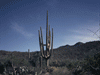
It had been over a year since the Corona Virus (Covid 19) had shut down the world and 21 months since we took a trip. Half the country had been vaccinated and things were feeling more normal. Everyone wanted to get out. It was predicted to be a busy holiday weekend but we had been planning this trip for years, so we took a chance and packed up. We got off 45 minutes late, as always, and headed north on I-5. It was another dry winter and the hills, usually green this time of year, were golden brown as we approached Gorman. We stopped at El Tejon Safety Rest Area before heading down the Grapevine. As we hit the floor of the San Joaquin Valley and I switch the player to two CDs of Sons of the San Joaquin. We were driving my twenty year old Sable wagon which has both a tape and CD player. As we continued north on I-5, we passed both productive agriculture and barren lands. Every farmer knows that climate change is real and the changing rain and snow patterns have created a drought. I saw many signs saying thing such as, "Make California great again. Build more dams." It's not lack of dams, it's lack of rain to fill the reservoirs behind the dams, most are empty.  Vista Point overlooking an aqueduct pumping station. We stopped for gas near Paniche (213 miles) and stopped at Colinga-Avinal Safety Rest Area. We usually pass a Vista Point overlooking an aqueduct pumping station north of John Erreca Rest Area and south of Los Banos, but I needed to stop anyway. Despite than man-made river, the surrounding lands were brown and dry. I took a few photos, checked my maps, and continued on our way. We turned west at California Highway 152 and noted that San Luis Reservoir was only 30 percent full and we were just finished with the rainy season. The drought is real. We passed Casa del Fruita where we stopped a few times when we weren't on a tight schedule and we wanted to stop at Gilroy Ostrich Farm, but didn't have time for that either. We entered Highway 101 and cruised north to I-85, and I-280 west. A few short runs finally brought us to the San Francisco Zoo about an hour behind schedule. Although we had completed the loop just as the zoo closed, the extra hour would have made a more leisurely visit. But that's jumping ahead a little. |
 All that remains of the Fleishhacker Pool.
| Somehow we missed a turn and ended up in a parking area on the other side of the zoo but decided to try again and found the paid lot, with better security and nearer the entrance. As my wife went ahead to scout out the line, I stopped to photograph a piece of ornate architecture on the west side of the parking lot. It was three sculpted free standing arches. A man from security saw me photographing it and pointed out an informational bit of signage explaining its history, It was all that remained of the Fleishhacker Pool which |
| once occupied the space now taken by the zoo parking lot. The arches had been the entry portal. I took a few more photographs and hurried to join my wife in line. | |
|
Because of Covid, we had to get timed tickets in advance so we waited in a long line, six feet apart, about 20 minutes to check in at San Francisco Zoo. By the time we finally entered the zoo, it was an hour after our time. We started with African Region including African Savanna, Gorilla Preserve, and African Aviary. The Savanna was interesting in design. Two tunnels connect to a central area surrounded by animals. As we moved around, we came to the enclosure where they were feeding the giraffe with their graceful necks and long tongues. We admired these animals a few minutes and moved on. |
 African Savana, Giraffe and Zebra.
|
 Velociraptor.
| We continued in a general counterclockwise direction through Cat Kingdom (lions, tigers, rhinos, bongo, and hippos), past the penguins, through the South American section and Bear Country. A little train gives rides and seemed popular, but we just didn’t have time. We turned a corner and there was a velociraptor and a small sauropod, sadly they were only fiberglass models and not live reptiles. We watched a hopping kangaroo and found a sleeping koala and it turned out we missed the feeding by only a hour. Some sections of the zoo were closed because of Covid and we |
| observed a children's play area with large sculpted artificial ice structures which we didn't have time to see closer. We were out of time so skipped Exploration Zone, much of which was closed anyway. | |
| By the time we left the zoo, the vehicles parked in front of the old Fleishhacker Pool entrance were gone and I took a few more photos before heading north on Great Road. It wasn't easy to follow my MapQuest directions to follow Great Road because it stopped and resumed several times, but eventually we reached the Presidio. Along the way I notice a parking lot near the beach at Golden Gate Recreation Area, west of the park, with free spaces and a nice view up the coast, so I pulled over. I took a few photos along the |
 Golden Gate Recreation Area
|
|
beach which included an old building hugging the top of the cliff. By this time it was after five and the beach was starting to empty of the people I'm sure were there a few hours earlier. | |
 Sign at Lincoln Boulevard entrance.
| We arrived at the San Francisco Presidio which was established by the Spanish in 1776. Once the United States took possession of California, the U.S. military used the site to defend San Francisco until it was recently decommissioned. Today the site is a large park enjoyed by the people of San Francisco, and a few visitors. The site is home to several museums, numerous historic sites, businesses, restaurants, and homes. Highway 101 runs through the park leading to the south end of Golden Gate |
| Bridge. It was well after 5 and most buildings were closed but the many military batteries and hiking trails were still being visited by people enjoying a new sense of freedom as the Covid threat diminished. | |

Battery Godfrey. Our first stop at the Presidio was at Battery Godfrey and Battery Boutelle which afforded a view of the military history and an unusual view of the Golden Gate Bridge, end on. It was quite windy so we didn't stay long. A short distance in we stopped a few minutes to photograph the only historic marker I could find that mentioned the Spanish origins of the Presidio and next to it, the old base hospital. Other historic buildings were clustered around. | |
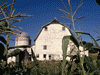
| We noted a military museum and the Walt Disney Family Museum housed in two of the historic buildings. Our original plan was to see The Walt Disney Family Museum that day, but the timed tickets were already sold out for the weekend by the time I tried to get tickets. Also among the building cluster is a lab for archaeology, restaurants, and other activities. Eventually I found the base chapel, a Spanish Revival structure about one hundred years old, a slight nod to the earlier Spanish occupation. |
 Base Chapel.
|
|
We then headed south to our hotel stopping for takeout dinner along the way. Because I didn't realize my wife had her GPS set to “no freeways” we got a much better view of the character of the city than we would have from Highway 101. I pointed out the Trolleybuses catenary wires above, but the only electric buses we saw were parked in a yard we passed on the way. We parked a few blocks from the restaurant so I got some exercised before eating our dinner of Thai food in the hotel room. We were on the 9th floor and I worked on my photos until it was time to settle in for a good night's rest. Day Two, Mission and Museum |

Apartment along Dolores Street.
| We arose early and got ready and went downstairs for breakfast. Because of the Covid pandemic, it was only pre-wrapped food to take back to our room. We ate and left for the day about 7:30 arriving at Mission San Francisco de Asís about 8:00. This was the last California Mission for me to visit a second time, the first time was in late afternoon and the lighting was bad. I waited over ten years to get morning photos. It was 8:15 by the time we were ready to enter the new church, but the doors didn't open till 8:30 so we had a nice |
|
visit with Peter who maintains the facade of the old Mission church. We took photos, attended mass, and toured the old Mission, founded in 1776. Mission San Francisco de Asis was the 6th Mission founded in Alta California by the Spanish and today all that remains is a small church and small cemetery. We were among the first visitors of the day to tour the Mission so were able to take photos without people in the way. We wandered through the seating area of the church, a small |
 The Basilica, the new church, at Mission San Francisco de Asis.
|
| museum space at the back, and then the old cemetery. The Mission cemetery is one of only three in the city, the rest having been moved out to reuse the space.. The contrast between the tiny original Mission church and the more recent Basilica beside it is striking. | |
 Front facade of the Mission church.
|
 The Cemetery, the small building at left is the Gift Shop.
|
| It didn't take long to reach Golden Gate Park where we would spend the afternoon. There was a bit of traffic and confusion but eventually we stumbled on the parking for the museums. We emerged from the underground parking to a large and busy space between the California Academy of Science and the de Young (art) Museum. We had time tickets for 1:30 at the California Academy of Science and this time we were a little early so we strolled around a large loop on the upper level of a large garden-like area. At the west end is a |
 Ferris Wheel in Golden Gate Park.
|
|
band shell and the eastern end has a large Ferris Wheel. Within the loop are gardens and lots of people enjoying a nice spring day. Just to add to the excitement, fire trucks arrived in response to a fire alarm that sounded throughout the area and was ignored by everyone. We returned to our car for a quick picnic in the car and headed back to the California Academy of Science. | |
| Once inside the California Academy of Science, we got oriented, reserved times for the forest exhibit and the planetarium show, and started exploring. We saw the shark exhibit and other exhibits at the west end, then it was time for the rain forest exhibit. This is a large sphere with a circular bridge around the inside edge and as we climbed, we saw various plants and exhibits. The occasional butterfly flew by, increasing in number as we climbed. We were surprised toward the top to see there were also colorful birds flaying around the treetops. Eventually we took the elevator down to the aquarium level. We wandered |
 Dinosaur with a Covid mask at California Academy of Science.
|
 The outside of the dome for the Rainforest at California Academy of Science.
| that enchanted level and relaxed as we watched the jellyfish. The aquarium section was large but eventually it was time for the planetarium show so we moved that way. It was good to get off our feet for a few minutes as we enjoyed the presentation. We thought we were almost finished when we discovered a galley lined with taxidermied animal dioramas and at the end, live penguins were enjoying their dinner. Then we discovered a small gallery lined with exhibits on gems and minerals. Now we were finished, until we discovered the living roof. The roof of the building is covered with a rolling lawn and a view. It was almost closing time as we returned to our car. |
After we left the parking, we drove west through the park trying to absorb the feeling. I wanted to see the two windmills at the west end of the park but my wife said only if I found easy parking, I did. I found a space not far from Murphy Windmill and we walked around it taking photos. The windmills, really wind pumps, were built to  Top of Murphy Windmill.
|
 Top of Dutch Windmill. pump up irrigation water for the park, but eventually they fell into disrepair. A few years ago, interest in the structures fueled a drive to restore them, first one, then the other. We got lucky to find parking at the northwest corner of the park to see the other windmill, the Dutch Windmill. We gave it equal attention and left for the hotel. |
|
For whatever reason, the day before we saw the power lines for the trollybuses, but no buses. I explained to my wife about them but it was hard with no buses. Today, there were buses and we followed one for several blocks so my wife could see for herself how they work and the ropes to the power intake poles to use when they come off the wires. As I drove east on Fulton Street between Webster and Octavia, I noticed I was |

Rear view of a Trollybus shot with the dash cam.
|
| driving over large yellow letters painted on the asphalt, "Black Lives Matter." | |
|
We drove a street (I won't say the name) which is more crooked than Lombard Street, but less landscaped and looked like there is two-way traffic but much too narrow. I'm sure the residence don't want tourists. Know it is there, but you don't need to see it. Maybe I will take photos next time. We had food left from the night before so we enjoyed leftovers in the hotel room for dinner. I organized my photos and we enjoyed a good night's rest. Day 3, The Long Journey Home We arose early and got ready. The foreground view out the window wasn't good, but in the distance, the sunrise was pretty over distant mountains and the bay. A few notes on Covid safety. They tell us the room was sanitized before we got there and no one entered the room besides us the two nights we stayed. The staff all wore masks as did most of the guests. Most people observed the two people per elevator rule. The dining area was closed and the usual continental breakfast was replaced with all pre-wrapped food. |
| We ate, packed, checked out, and headed home about 7:30. We had wanted to visit Coit Tower on the way home, but it was still closed because of Covid. We headed south on 101 and then east on Highway 92 and over San Mateo-Hayward Bridge. We stopped for gas near Livermore, drove through the Altamont Pass with its wind farm, and joined with I-5 south. We made a quick stop at a rest area in Stanislaus County, another at a Vista Point a little north of the Stanislaus County line, |
 Wind Turbine in the Altamont Pass.
|
 Vista Point along the southbound sid of I-5.
|
 Peasoup Andersens.
|
 The hills behind John Erreca Rest Area
|
|
and entered Merced County. We called ahead for an early lunch at Pea Soup Andersen's and ate it at John Erreca Safety Rest Area a few miles south. As we drove through Fresno County, I noted how the San Joaquin Valley was a checkerboard of land in and out of agriculture. A large percentage of the nations food comes from here and not everyone appreciates it We stopped at a Safety Rest Area near Buttonwillow and also got gas. We had left the Bay Area early and maybe |
 Buttonwillw Rest Area.
|
|
that is why we encountered less traffic than usual as we approached the junction of I-5 south and Highway 99 south. We arrived home about 4:30 giving my wife a few minutes to settle before tutoring a client at 5:00. This had been our first trip in almost two years and we were happy that life was starting to return to normal. Despite the lingering Covid-19 issue, we managed to do Day Two about as planned and made substitutions for Day One. Day Three, we cut Coit tower and got home a few hours earlier. We felt it was a successful trip. Total miles 793. | |

|

|

|
| Note:This is not the official site for any of the places shown in Places Earth. Places Earth is not responsible for accuracy of the information. Hours of operations, prices, exhibits, and sometimes locations are subject to change without notice. |
|
Support this Web Site I hope that you find this web site helpful. It started because of my love for Architecture and interest in History and a desire to share my photographs and tales of my adventures. I don't allow paid advertising. This web site is for your benefit and enjoyment and I make no profit on it. For twenty years it has been supported primarily from my regular paycheck as a Set Designer. If you are in the need of a designer, please see my Set Designer portfolio site Set Design Portfolio. |
|
Links |

|
This site maintained by Kenneth A. Larson. Copyright © 2004 - 2023, Kenneth A. Larson. All Rights Reserved. Website content including photographic and graphic images may not be redistributed for use on another website. |

|

|

|