Places, Earth
Lake County, California
Lake County, California
|
|
Places, Earth
Lake County, California |
|
|
Day One, Take Me to the Fair Again my wife chose to stay home with her dogs so Isabel, my Mustang, and I went north. It was predicted to be 100 degrees in Lake County, but hotter in the San Fernando Valley, so I went anyway. There was a bad wildfire at Lake Hughes, north of Castaic, with two of the three north bound lanes of Interstate 5 closed. The backup extended five miles south to Santa Clarita. I sat back, enjoyed some classical music, and tried not to hit the car |
 Emergency vehicles beside the fire next to I-5. |
 Restroom building at the northbound side of Tejon Pass Safety Rest Area.. |
ahead of me. Eventually I passed two miles of burned hill sides, emergency vehicles, and a few small wisps of smoke. It only took an hour to go those five miles. A few miles later, the south bound travelers were enjoying their own delay at a truck over the side. I was finally moving north. I stopped a few minutes at Tejon Pass Safety Rest Area, mostly because I couldn't find my CDs. I loaded Sons of the San Joaquin and a few minutes later I descended into the immense San Joaquin Valley. I couldn't stop thinking how much |
 Entrance to Coalinga - Avenal Safety Roadside Rest Area. |
flatter the San Joaquin Valley is than the plain of west Kansas that I had driven through only a week before. Farmland and barren land passed behind as I drifted north on I-5. Just north of the Fresno County line I stopped at Coalinga - Avenal Safety Roadside Rest Area mostly to walk around. I pass a sign, "Build more dams, stop the man made drought." This ignores the fact that the drought is caused by less rain to store behind those dams. |
|
Just north of the Merced County line, the rest area was being rebuilt and there was nothing more than a slab and some pipes. I stopped a minute at Dos Amigos Vista Point to see if there was less trash than last time, there wasn't. I continued north. I stopped at another Vista Point in Stanislaus County but I didn't catch the name. There are two tricky spots on I-5 where I-5 is not the obvious way at a fork. One is the Highway 99 split just north of the Graapevine. The other is the I-850 split |
 Information signage at Dos Amigos Vista Point. |
 Information signage at Patterson Vista Point. |
near Tracy. I messed up here the first time and drove toward San Francisco instead of north for about twenty minutes. Traffic slowed in Stockton. This allowed me to take a quick look at draw bridges and ocean going ships. Stockton is the furthest inland ocean port on the West Coast. I continued north. Traffic slowed a little in Sacramento. Sons of the San Joaquin were still playing as I entered the Sacramento Valley. I passed |
|
Sacramento Old Town to my left. I got gas in Woodland. I loaded disk 9 of Return of the King, where I left off in the previous trip, only a few days earlier. At Williams I left I-5 and turned west onto Highway 20. About 4:00 PM I checked into my hotel, unloaded a little, and headed to the Lake County Fair in Lakeport. |
| I live in the county with the largest county fair in the country and I like to visit smaller, simpler county fairs with 4H projects and quilting displays instead of patio covers and massage chairs. I also have spent very little time in this part of the state. Once inside the fair I began touring | |
 Floral Pavilion. |
 One of many quilts on display. |
| the several buildings of displays. First was the Floral Pavilion with what you would expect, arrangements, some including local vegetation. Next were some works of art in the Quilt Pavilion. The Home Pavilion (I may be getting some of these mixed up since I broke my tablet after the first pavilion and stopped taking notes) included food items, table arrangements, | |
| children's art projects. As a retired professional model maker, I do have to remind myself that some of these projects are by children. I forget which pavilion had a table for local historic sites, one open tomorrow. There was a small building discussing fire safety in this area surrounded by dry brush, drought, and rising temperatures. An entire pavilion was devoted to art and photography. I spent the most time in this building with all sorts of creative works and wonderful photographs. I spent several minutes talking with an older new artist with beautiful |
 Resting Pig. |
| abstracts in acrylic. He made me want to retire and get creative. My favorite section of any fair is the animal barns. Small animals such as poultry (which makes me miss my pet chickens), rabbits, and Guinea pigs (my wife's favorite) filed one barn. My favorite animals are pigs, they have a built in smile. Sheep, goats, cattle, and horses were also fun to see. Baby pigs and goats are so cute. I was about to leave when the Demolition Derby started. I watched a few minutes but decided I rather get back to the hotel before dark, it got dark half way back. |
 Truck and boat at the Demolition Derby. |
|
I settled in, copied my notes from my smashed tablet (that still worked) to my computer, and sorted my photos (also using an older camera since my newer camera malfunctioned at the end of the previous trip and there wasn't time to fix it between). Day Two, History I arose, got ready, enjoyed breakfast, and waited an hour for church. I found the church with some difficulty. I got lost following Mapquest directions over poorly maintained residential streets, I returned to the hotel along the main street on which my hotel was located. |
|
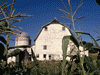
First I drove to Anderson Marsh, but first I had to drive to a convenience store for change for the honor system parking, which always frustrates me. In addition to many acres of hiking lands, there is the house and surrounding constructions. The house is not open but you can walk through the barn. There is an exhibit about the outhouses and the windmill. I wandered a half hour and moved on. I left the marsh and was suppose to turn right onto Highway 29 north but went |
 Front of house at Anderson Marsh. |
|
straight onto Highway 29 south and drove 30 miles before I realized. Then the Maps Ap got me back on
course, following a slow twisting mountain road. Eventually I found the Old Lake County Courthouse, which was closed. Yesterday the woman at the fair from the Historical Society assured me it would be open. I photographed the exterior and a few statues and markers and left. I then drove the rest of the way around Clear lake, stopping several times for photographs. The most striking stop was at Lucerne Harbor Park. The name says Harbor but there is no harbor. The lake level has dropped to below the floor of the harbor. And some people believe climate change is a hoax. One last stop was the Lower Lake School Museum, also closed. I wandered a few minutes photographing the grounds and buildings and continued on. I returned to my hotel early and got ready to drive home tomorrow. |
 Front facade of the Old County Courthouse. |
 Several years earlier I took this same photograph at Alpine Park with water in the harbor. |
 Right facade of the Lower Lake School Museum. |
|
Day 3, The Drive Home I arose early, got ready and checked out. It was an hour before sunrise as I headed east on Highway 20. On Highway 20, two days earlier, I had noticed a small sign for a historic | |
|
point of interest. I didn't want to take the time then, but decided to check it out now. It turned out to be
Sacramento Valley Museum, a history museum in Williams. It wasn't open this early so I took a
few photographs of the exterior and continued. On the way to I-5, I photographed the Williams
Arch against the sunrise. Finally on Interstate 5, I headed south, stopping a few minutes at Deputy Tony Diaz Memorial Rest Area, a small but useful stop. |
 Deputy Tony Diaz Memorial Rest Area |
 Refurbishing at Larry Combs Rest Area. | A little south of Sacramento I saw several birds on the side of I-5 that I think were wild turkeys. I got gas at Thornton and cruised south. A short stop at Larry Combs Rest Area which was still undergoing work. The rest area north of the Merced / Fresno line was still closed for rebuilding. As I pulled into the Coalinga- Avenal Rest Area, I finished the audiobook, The Return of the King, that I had started during the previous trip. Sons of the San Joaquin serenaded as I slowly climbed south out of the San Joaquin Valley. Two hours from home, the landscape passed slowly behind. |
|
Although not far from home, I've driven past Fort Tejon State Historic Park dozens of times but either it was after hours or I didn't have time to stop. I had made good time today and decided
today I would stop. I wandered about an hour photographing the buildings, other constructions,
and landscape. Satisfied, I continued. A quick stop at one last rest area, Tejon Pass Safety Rest Area, and onward. The Interstate ran through the area of the burn by the recent fire and although my |
 A large building at Fort Tejon. |
|
direction was largely unimpeded, going the other way (north), the way I had gone three days earlier, was backed up many miles. I
had sympathy for the people stuck in traffic, at least it wasn't over 100 degrees when I went
through Saturday morning. Finally home, my family was happy to have me back. My dog took a nap with me. Till next time. |

|

|

|
| Note:This is not the official site for any of the places shown in Places Earth. Places Earth is not responsible for accuracy of the information. Hours of operations, prices, exhibits, and sometimes locations are subject to change without notice. |
|
Support this Web Site I hope that you find this web site helpful. It started because of my love for Architecture and interest in History and a desire to share my photographs and tales of my adventures. I don't allow paid advertising. This web site is for your benefit and enjoyment and I make no profit on it. For twenty years it has been supported primarily from my regular paycheck as a Set Designer. If you are in the need of a designer, please see my Set Designer portfolio site Set Design Portfolio. |
|
Links |

|
This site maintained by Kenneth A. Larson. Copyright © 2004 - 2023, Kenneth A. Larson. All Rights Reserved. Website content including photographic and graphic images may not be redistributed for use on another website. |

|

|

|