Places, Earth
Road Trip - Wildflowers and Oil
Road Trip - Wildflowers and Oil
|
|
Places, Earth
Road Trip - Wildflowers and Oil |
|
|
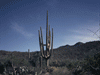
We got off a little after 7 on Good Friday morning. We headed north on I-5 through the Grapevine and the Highway 99 split to exit at Highway 166. We headed west into the oil country
of western Kern County, through Maricopa, to Soda Lake Road. We turned north onto Soda Lake Road, crossed the line into San Louis Obispo County, and entered Carrizo Plain National Monument. The Carrizo Plain is about 50 miles long from north to south (between Highway |
 Fields along Highway 166 Fields along Highway 166
|
| 58 and Highway 166) and about 15 miles wide at the widest point, the National Monument is about 385 square miles. It is the largest native grassland left in California and contains several archeological sites and National Historic Landmarks. Although we didn't visit this time, in a previous visit we visited Wallace Creek, a site where the San Andreas Fault cuts across canyons and it's easy to see how the plate on the west is slowly moving north. It was established as a National Monument in 2001. | |
| Most of the southern end of Soda Lake Road is unpaved, but not too rough. We headed north looking for wildflowers. We had a lot of rain this winter and the wildflowers were better than usual and as the day progressed, more visitors arrived. We stopped many times | |
| to photograph the flowers. There was one spot where there is a deeply eroded gully on one side that I photographed alone that was filled with cars and people that afternoon on our return. We drove past the Traver Ranch, one of the old ranches that once operated in the valley. We had visited years earlier so we skipped it. We stopped at KCL Campground to use the dry toilet. This was another former ranch, Kern Cattle and Land. We continued north stopping for more photographs. |
 KCL Campground |
|
We stopped for some time at a spot in the road with a number of cars and in the large expanse of yellow flowers on both sides of the road, were dozens of people enjoying the display. We finally reached Goodwin Education Center for a few answers and photos. I was told that Elkhorn Road, on the east side of the park, was not suitable for my car. I had planned to return that way so we continued a little further north to Soda Lake for a few last photos and headed back. We made three more stops on the way back. There was another large patch of wildflowers |
| North and east of the Education Center and south of Soda Lake where we stopped a few minutes. We stopped again at KCL Campground for a picnic lunch. Further south I started down a trail to a purple patch of flowers but decided it would take too long to reach it, so I turned back. We finally reached the south entrance where we had entered and headed back east on Highway 166 toward Maricopa. |
 Purple Flowers |
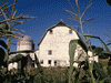
| Taft is the only sizeable town in this part of Kern County and serves the oil industry. We only had about a half your to run through West Kern Oil Museum which is filled with old oil industry equipment. At the center of the outdoor area is a recently reconstructed wooden oil Derrick over 100 feet tall. I would have liked another half hour but the museum was closing. |
 Drilling Rig |
| We found the Oilworkers Monument at the corner of Supply Row and 6th Street and took a few photos. Next we found The Fort which is a reproduction of Sutter Fort. The Fort is a collection of government offices and businesses. We wandered the place for about 20 minutes. Most everything was closed and we didn't see anyone else. Of some curiosity was the old jail from McKittrick off on one side. |
 Oilworkers Monument |
| We had one last stop. McKittrick is another town in western Kern County that is slowly diminishing. The most significant destination is Mike and Annie's Penny Bar in the McKittrick Hotel. When Mike and Annie bought the bar, Annie asked Mike to cover the bar with pennies. Once the bar top was covered, Annie clarified that she wanted everything in the bar covered, floor, walls, TV, pool table, and almost any surface that wasn't glass or a light. We enjoyed our dinner and headed home, arriving a little after dark. |
 Penny Bar |

|

|

|
| Note:This is not the official site for any of the places shown in Places Earth. Places Earth is not responsible for accuracy of the information. Hours of operations, prices, exhibits, and sometimes locations are subject to change without notice. |
|
Support this Web Site I hope that you find this web site helpful. It started because of my love for Architecture and interest in History and a desire to share my photographs and tales of my adventures. I don't allow paid advertising. This web site is for your benefit and enjoyment and I make no profit on it. For twenty years it has been supported primarily from my regular paycheck as a Set Designer. If you are in the need of a designer, please see my Set Designer portfolio site Set Design Portfolio. |
|
Links |

|
This site maintained by Kenneth A. Larson. Copyright © 2004 - 2023, Kenneth A. Larson. All Rights Reserved. Website content including photographic and graphic images may not be redistributed for use on another website. |

|

|

|