Places, Earth
Indio to Lucern Valley, 2023
Indio to Lucern Valley, 2023
|
|
Places, Earth
Indio to Lucern Valley, 2023 |
|
|
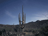
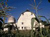
Indio to Lucern Valley, 2023 We had planned this trip since 2020, then canceled for scheduling reasons, then Covid hit. This year I would try again. My wife decided to pass again so I was off on my own. Day One, A Fair Day I departed at 8:15, ripping myself away from my family including three adorable kittens. I journeyed east on 210 and I-10, made a quick stop at Wildwood Rest Area, and on I traveled eastward. I arrived at the Riverside County Fair and National Date Festival about 11:00 AM and began wandering for several hours. I visited the Taj Mahal Pavilion with Agricultural exhibit including displays of dates, citrus, vegetables, and farming equipment. I chatted with a woman at the Vector Control booth about mosquitoes. I moved on to the Merchandise Pavilion where I watched a demonstration on Kitchen Craft Waterless Cookware. I had a few pieces already, but was interested in one or two more pieces. I enjoyed the Crafts and Hobbies Pavilion with several displays by the Coachella Valley Model Railroaders. It saddens me that this great hobby is losing appeal. My career began with 18 years as a professional model maker, honed by my early days of building model railroads. Today people would rather play video games. The Gems and Minerals Pavilion is filled with just that, worked and natural gems and minerals and gem based jewelry. One section demonstrated how perfectly shaped spherical minerals are made. Junior Exhibits is filled with a variety of projects by aspiring artists and craftspersons. The Queen's Gallery was filled with art. In keeping with the "Date" theme, there are some buildings in the Moorish Style and I photographed some of them. Eventually I found the Livestock Barns. Last year there was no fair, just a carnival. This year was more like a traditional fair, but the Livestock Barns seemed a little empty. Still, there were some pigs and sheep and a row of fowl. There is a large stadium but this early, nothing was performing there yet. There is another permanent stage with entertainment and there were other smaller temporary stages. I was working my way out when I found the Pig Races. These are always fun and once completed, I headed out. As I turned the car key, I received a text from a friend reminding me of the Date Shakes. Oh well. It was not far to the hotel where I settled in after getting gas. Day Two, A Walk in the Park I awoke early, as always. At least I couldn't blame the cats this time. It was still early by the time I was packed, but there was no reason to stay, so off I went. I entered the south entrance to Joshua Tree National Park and arrived at Cottonwood Visitor Center a little after 8:00 AM, but since it wouldn't open until 8:30, I made a side trip to Cottonwood Spring a short distance at the end of a side road. This is a trailhead to Lost Palms Oasis, but I wasn't interested in the four mile trail. With the Visitor Center now open, I stopped a few minutes to use the restroom and take a quick look, and hurried northwest. There are several scenic stops, but I had seem most of them before so I continued. There was only one primary goal for this final visit to the Park, Barker Dam. The dam is about half way along a one mile loop trail. It is a small simple dam that once held a small reservoir and provided drinking water to cattle, but then the climate got drier. About two-thirds along the trail is a small site with petroglyphs. I finished the trail, got back in my car, and from here I continued to the west entrance where the line to get into the park was about an hour or two long. It would be several hours before I could check into my hotel so I first stopped at the Twentynine Palms Visitor Center. I spent the next several hours sightseeing around town. There were a few new murals but one that I had previously missed is within the highschool campus and not accessible. I got a better photograph of the mural at the skateboard park and the mural at Oasis of Mara was visible (a car blocked it on a previous visit). Since my previous visit, a new Cultural Center had opened so I visited that to learn about the people native to this land..The Foster's Freeze had closed and I was running out of locations to visit. I was still way ahead of schedule but was now able to check into the hotel, and so I did. I spent the rest of the afternoon and evening relaxing, something I almost never do. Day Three - Sliding Home The following morning I arose, got ready, and checked out. I started traveling west on Highway 62, then north and west on Highway 247. Eventually I reached a spot about ten miles east of Lucern Valley where to the south is a large patch of rock that looks out of place. This is the remains of the Blackhawk Landslide which occurred about 17,000 years ago when a large section of the north facing San Bernardino Mountains collapsed creating a deposit about five miles long, two miles wide, and thirty to one hundred feet thick, one of the largest known events in North America. At least it wasn't moving today. Just west of Lucern Valley I stopped a minute at a historic marker at Chimney Rock toward the last "Indian" battle in Southern California. I found the home of a friend and we visited two hours before I continued west. The Maps on my phone took me west through a section of the southern Antelope Valley that I had never traveled through before. Finally I merged onto Highway 14 south and arrived home a little before 3:00. I was greeted at the door by three kittens glad to have me home. This trip had been a bit slower paced than most of my trips but I did wrap up a number of lose ends. Two days later, I took the 22 year old station wagon that I had used for this trip to the transmission shop. I made it home in time. Till my next magical trip... |

|

|

|
| Note:This is not the official site for any of the places shown in Places Earth. Places Earth is not responsible for accuracy of the information. Hours of operations, prices, exhibits, and sometimes locations are subject to change without notice. |
|
Support this Web Site I hope that you find this web site helpful. It started because of my love for Architecture and interest in History and a desire to share my photographs and tales of my adventures. I don't allow paid advertising. This web site is for your benefit and enjoyment and I make no profit on it. For twenty years it has been supported primarily from my regular paycheck as a Set Designer. If you are in the need of a designer, please see my Set Designer portfolio site Set Design Portfolio. |
|
Links |

|
This site maintained by Kenneth A. Larson. Copyright © 2004 - 2023, Kenneth A. Larson. All Rights Reserved. Website content including photographic and graphic images may not be redistributed for use on another website. |

|

|

|