Places, Earth
Hetch Hetchy, 2023
Hetch Hetchy, 2023
|
|
Places, Earth
Hetch Hetchy, 2023 |
|
|
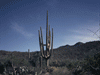
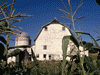
Day One, Getting There A year before I had attempted this trip. After a stop near the south entrance to Yosemite National Park, I arrived at the entrance to the road to Hetch Hetchy about 3:00 pm and was told they locked the gate at 5:00 and I had to be out by then. This did not allow time for the six miles round trip to the waterfall, so this year I was trying one last time. I left at 7:45 AM heading north on Interstate 5. I stopped at Tejon Pass Rest Area and took the I-5 leg at the I-5 / Highway 99 split. I skipped the Butonwillow Rest but stopped at Coalinga Avenal Safety Roadside Rest Area. I listened to Sons of the San Joaquin as I drove north through the San Joaquin Valley. The highway was lined with signs saying things like "Build more dams, stop the man made drought." The drought is human made, but not because of fewer dams, but too much carbon in the atmosphere put there by us. More rain, more water. I had driven Interstate 5 twice last year and Highway 99 once, so to make it a little different, I exited Interstate 5 at Highway 33 north, Exit 349 which went north to intersect Highway 99. I drove past fields, orchards, and empty land. I passed between solar panels and past a prison. I had heard of Mendota and Firebaugh, today I drove through them, and got gas in Firebaugh. I crossed into Merced County about 12:20 and a few minutes later stopped to photograph an old barn with a tree growing up through the shingleless roof. I crossed into Stanislaus County at 1:35 PM and at Merced I moved right a few blocks and followed G Street as it changed to Snelling Road. I had passed through Snelling last year and stopped to get gas and photograph the library and courthouse then, but today I pushed on. I followed La Grange Road north to Highway 108 east. I stopped a few minutes in Jamestown and visited Rocca Park with a small museum, jail, gazebo, and other mining related objects. I continued along Highway 108 east to my hotel in Sonora. After unpacking and resting, I attended Mass in Twain Harte, got gas in Soulsbyville and returned to my room for the night. I downloaded my photos, worked on this article, ate, watched a video, set my alarm for 5:00 AM, and fell asleep. Day Two, Hetch Hetchy I awoke at 4:00 AM and started to get ready. I got the car ready, ate, and left for Yosemite about 6:45 I started west on Highway 108, then south on Highway 49 to Highway 120 east. Eventually I turned left onto Evergreen Road. This is not a well maintained two-lane highway. It is more like a lane and three-quarters, a little rough, and tight turns. About ten miles of bouncing and I entered Yosemite National Park about 8:45 and began the ten miles to Hetch Hetchy which took another half hour. Last year I arrived at 3:00 PM and was told that I had to be out by 5:00 PM, this year I had till, 9:00 PM and was out a little after noon. I parked a few hundred feet uphill from the end of the dam and started across. Last year I walked the first quarter mile and it was smooth and level. Turns out it gets rougher. There are three significant waterfalls along the trail. Tueeulala Falls is more of water running down the cliff face in a feathery way. Wapama Falls is the easiest to see from the dam and many places along the way. It was running strong and the Park Service advised going no further. A few miles beyond is Rancheria Falls, too far back to see from anywhere I noticed. The trail switched back at one point and alternated between rough rocky and smooth rocky, but generally followed the shore. I came to a fork in the trail, 1.6 miles to the falls. At 10:00 I got as close as I was going to go because the trail was flooded. There is an upper fall that is easy to see from the dam and most of the trail and a lower fall just around the corner. I missed the end by a few hundred feet but it can be seen from the dam. I couldn't find a bus back so I turned around and hiked back. About half way back I rested as I put my camera back in the bag and took my sweater off. I finally reached the fork in the trail and knew I was two-thirds back and the last third was easier. Back at the car, I used a restroom and headed to Groveland. I'm glad I came early because there was a long line of cars heading into the park as I left. Highway 120 runs through Groveland which was a major settlement along the Hetch Hetchy Railroad that was built specifically to built the O'Shaughnessy Dam. It had been a gold town and today is popular with tourists. I stopped an hour at Groveland Museum with exhibits on local history and nature. I parked and walked a few blocks and peaked inside Iron Door Saloon, which claims to be the oldest saloon in California. On the way back to Sonora I stopped to photograph a marker for Montezuma, a former town and to get gas in Jamestown. I arrived back at the hotel about 3:30 PM and relaxed the rest of the evening. Day Three, Homeward Bound. I arose at 4:00 AM and got ready, ate, packed the car and checked out. I started back the way I had come, west on 108, south on La Grange through Snelling, south on Snelling Road to Highway 99 south. A little south of Snelling I hit a slight delay. Traffic was stopped for about twenty minutes as a real cattle drive of maybe a thousand head crossed the road. There were maybe a dozen cars ahead of me and by the time we got the all clear, there were dozens of cars behind. Since no cars were moving from either side, I shut the engine off and took photos and videos of the cattle running by on the other side of the fence with cowboys and cowgirls, horses, dogs, and ATVs keeping them moving. Finally the last animal was across and the road was reopened and we continued. Once on Highway 99, it was basically driving south through the San Joaquin Valley, listening to two CDs of Sons of the San Joaquin, Phillip S. Reins Rest Area was closed, I stopped for gas and a restroom break in Earlimart, and I arrive home a few minutes before noon. Total miles: 793. |

|

|

|
| Note:This is not the official site for any of the places shown in Places Earth. Places Earth is not responsible for accuracy of the information. Hours of operations, prices, exhibits, and sometimes locations are subject to change without notice. |
|
Support this Web Site I hope that you find this web site helpful. It started because of my love for Architecture and interest in History and a desire to share my photographs and tales of my adventures. I don't allow paid advertising. This web site is for your benefit and enjoyment and I make no profit on it. For twenty years it has been supported primarily from my regular paycheck as a Set Designer. If you are in the need of a designer, please see my Set Designer portfolio site Set Design Portfolio. |
|
Links |

|
This site maintained by Kenneth A. Larson. Copyright © 2004 - 2023, Kenneth A. Larson. All Rights Reserved. Website content including photographic and graphic images may not be redistributed for use on another website. |

|

|

|