Places, Earth
Gold Country, 2019
Gold Country, 2019
|
|
Places, Earth
Gold Country, 2019 |
|
|
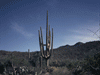
Day One, Of Trains, Trees, Buildings, and Camera Trouble. We got off 45 minutes late. Have we ever left on time? I backed my loaded 2001 Sable wagon out of the driveway, past my 2016 Mustang, hoping we weren't making a mistake taking the older car on a road trip, but she rides smoother, is bigger, and MPG is about the same. Heading north on I-5, we enjoyed seeing the rolling golden hills of California (refer to the song The Redtail Hawk by Kate Wolf), listening to Susan Vega, and stopping at the Lebec Rest Area. As we entered the San Joaquin Valley, I switched to a CD of Sons of the San Joaquin which is a tradition with us. We continued north on Highway 99 past fields, grain silos, and equipment dealers. As we drove through Pixley, I thought of Green Acres, which is also near here. We drove past fields of corn and it reminded me of our trip to Iowa two years ago. Highway 99 passed by beneath us as we cruised north. We stopped for gas at Selma, "The Raisin Capitol of the World". At Fresno, we turned east onto Highway 41 and started slowly climbing into the foothills of the Sierra Nevada Mountains, appropriately, we finished Sons of the San Joaquin and a Nancy Griffith CD started playing. We passed through Oakhurst, the southern terminus of Highway 49, the Gold Highway, but we would be back soon. |
| We arrived at Yosemite Mountain and Sugar Pine Railroad about 11:30 and bought two round trip tickets for the 1:00 train. They have events here and there were plenty of picnic tables adjacent to the track. Shortly after starting our picnic lunch, the 11:00 train returned. I took a few photos as they ran the locomotive to the other end of the train and we finished eating. While waiting for the 1:00 train, we also looked around the site and wandered through the Thornberry Museum with its collection of artifacts collected in the area. We skipped |
 Shay Locomotive #10. |
| the gold panning, done that before. After a few more photos, it was time to board the train. We passed through trees around a horseshoe curve while listening to narration. Among the trees found here are Sugar Pine, White Pine, Fir, and Black Oak. We were riding in a train pulled by Shay locomotive #10, built in 1929. A Shay has gears on one side with an off center boiler and while not fast, they are very powerful and take tighter turns than side rob locomotives. | |
| At the midpoint of the trip, the train stopped for water, a blowdown, and a fifteen minute break. Logging tracks were rearranged to following the logging but in 1931 operations ended. I'm not sure when the railroad started running as a tourist destination but I remember riding past in the car many times on family trips to Yosemite National Park, wanting my Father to stop. Finally a few years back, my wife and I stopped but the locomotive had been put away for the day and we road a Jenny Car to this same turnaround spot. I had waited a long time for this ride. It was only before the train began the return trip that the conductor came through to punch tickets. Any stowaways would have had a long walk back. The Shay climbed back up the slope to the station along the same track we had just descended. Once the train returned, we continued up Highway 41 just a few miles and entered Yosemite National Park. |
 Pioneer Yosemite History Center | I flashed my lifetime senior pass and we drove on to Wawona and Pioneer Yosemite History Center. This often missed jewel is a collection of old building significant to park history, gathered to this location. You start at a gray barn which would hold square dances in the evening, and a shed filled with wagons once used in the area, then cross a tall covered bridge that opens to the collection of buildings. There was a blacksmith demonstration and we talked with the artists for a few minutes. An interpreter in the Wells Fargo building |
|
told us about the telegraph and telephone switch board. Later I discovered that my camera had malfunctioned and overwrote half the photos here, so maybe we will return. A man at the Gray Barn told us of a swing bridge three miles up the road and after a 300 yard trail. My wife was upset that I dragged her up and the bridge was disappointing anyway. One point for Joy and the camera also deleted all these photos. |
 Swing bridge. |
| We headed to the Mariposa Grove which was not how I remembered it. Ten or more years ago, we started up the trail but when it started to rain, my wife turned back. Today we parked in a remote lot and took a shuttle which dropped off somewhere else. We started up the trail and hiked about half a hour and finally came to a road that is only open when the |
| shuttle isn't running. I think this is where we parked all those years ago. There are many more trails and I estimate we only saw a fifth of them and could have spent two or three more hours. This is the largest stand of Sequoia trees in Yosemite National Park. A few years ago we visited Sequoia and King's Canyon National Parks which have more and larger Sequoia trees. Sequoia trees are the largest living organism, larger than the biggest dinosaur or whale. They are adapted to a dry climate, can absorb hundreds to a thousand gallons of water a day, are fire resistant, and can live thousands of years. The mostly uphill trail was shaded and we marveled at these immense trees. We passed a deer fearlessly browsing near the trail and further on, a mother deer and two fawns seemed also to trust the people taking photos. My wife was tired and it was late, so we turned around. |
 Mariposa Grove. |
|
We headed out of the park and back to Oakhurst and from there turned north in Highway 49 toward the town of Mariposa. Several years ago we drove the middle section of Highway 49, so this was our first time to experience the section south of Sonora, which we would cover in the next two days. Just before arriving in Maripoosa we passed the fair grounds and it was fair weekend - more on that later. Years earlier we had spent a night in Mariposa taking the long way home from Bishop but got in late and had to leave early the next day. We had a little more time this trip. We checked into the Best Western at the junction of Highways 49 and140 at the south end of town and started searching for the restaurant where we had eaten years earlier. I think we found it but it had changed so we enjoyed a Mexican dinner at Don Rubens. We enjoyed a restful night. Day 2, A Fair Day for History I awoke early and started getting ready. The continental breakfast room was already filled when we entered just 15 minutes after the doors opened, must have been the holiday weekend. |
| I attended Mass at Saint Joseph which is a historic church from the late 1800s and maintains the historic charm. We checked out of the hotel and drove the two or so miles to the Mariposa County Fairgrounds. I hadn't realized it was fair weekend when I made the hotel reservations but we were excited when I realized it was. Coming from Los Angeles with several large fairs in the area, we love smaller county fairs |
 Saint Joseph Catholic Church. |
|
where you can see everything before you get tired and the people are so nice. | |
| The gates were open, but we had a few minutes before the exhibit buildings opened. We started with the merchants building and had some pleasant conversation with, among others, proponents of the State of Jefferson trying to split off northern California and southern Oregon into a new state ( see two previous road trip articles: Jefferson 2008 and Jefferson 2009), the Democratic Party, and a woman promoting canning and drying of fruit, vegetables, and herbs. We would come back later for the fudge. |
 Mariposa County Fair. |
 California State Mining and Mineral Museum. | Even before we realized it was the fair weekend, we planned to visit the California State Mining and Minerals Museum which is housed at the fairgrounds, so that was our next stop. We spent about an hour at the museum, talking with the staff and docents and viewing the minerals and exhibits. I was only allowed to photograph exhibits not showing minerals for security reasons after a theft a few years ago, still, I photographed mining tools, a working model of a stamp mill, and other items not showing the mineral collection. The pride |
| of the collection is the Fricot Nugget, not really a nugget, but a specimen of branching intricacy. It is one of the largest such pieces not melted down and is worth more than its weight in gold, which is 201.4 troy ounces. It was found August 1865 in a grit claim at Spanish Dry Diggings in El Dorado County. It is in a safe in a vault and I hope quite safe. | |
| We left the Museum and wandered the animal displays. The poultry barn seemed empty which disappointed, but the sheep, goats, and pigs were so cute. The rabbits were also cute, the cows maybe less so. We enjoyed the building with photographs and art. It always makes my own art and photography seem simple when I see the creativity of others. We walked past the farm equipment and other outdoor exhibits, in Los Angeles, they sell hammocks and patio covers. We had seen everything we wanted to see, so we stopped to buy two small pieces of fudge and returned to our car. |
 Pig Barn at the Mariposa County Fair. |
|
On the way to the Mariposa Historical Museum, we made two stops, the Old Mariposa Jail on a little knoll and the Mariposa County Courthouse, the oldest still operating in the state. What looked like a more recent wing of the Courthouse is what I'm guessing is a newer jail, based on the solid metal windows. | |
 Old Mariposa Jail. |
 Mariposa Courthouse. |
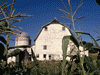
 Mariposa County Historical Museum. Stamp Mill at left. | Years earlier we had spent a night in Mariposa just passing through, so I had only seen the Mariposa County Historical Museum from the outside, today is was a planned stop. There are indoor and outdoor exhibits and while my wife went inside, I photographed some wagons across the street. Among the outdoor exhibits is an occasionally running full size stamp mill which, I am told, rattles the surrounding neighborhood when in use. The exhibits cover both mining and non-mining history and you can borrow a binder that is the self |
| guided tour. Outside we walked the veranda around to the back and down a flight of stairs to more outdoor exhibits including some buildings and equipment. We were finished with Mariposa for this visit and continued north on Highway 49. | |
| As we passed through Bear Valley I noticed a roadside marker. My wife groaned as I pulled over to read it. The town isn't large and there seemed more ruins than open buildings. A woman from the Bon Ton Café called me over hoping to land a customer. I offered my apologies but she did give me a brochure on the history of the town. There is a lot of history in this small town and I regret that we didn't have time for a longer visit. I'd like to spend more time in a future visit but for today, we needed to get to Sonora. |
 Bon Ton Café and Cavagnaro Store in Bear Valley, a small town in Mariposa County along Highway 49. |
| Following Highway 49 we encountered a steep winding grade down to the Merced River. My wife doesn't like roads like this and was glad that I drove slowly around the tight turns. The bridge over the river was the straightest section for a while. We climbed an equally winding road back up the other side of the valley and while my car made it, I watched the temperature gauge closely and was thinking about pulling over when I saw the summit just ahead. The car was grateful as we reached the top and started back down. |
 Highway 49 crossing the Merced River at the bottom of a long grade down and back up. |
 Whistling Billy in front of Northern Mariposa County History Center on Highway 49 at the junction of Highway 132 in Colterville. | A little further north we stopped again at Coulterville, attracted by an old building with a demure locomotive in front. This is the Northern Mariposa County History Center which is housed in the still functioning half of a historic hotel, a model of which is in the center of the main galley space. Typical of similar museums, there were tools and household goods of one hundred and fifty years ago. We were still on a tight schedule so we pressed on north on Highway 49. |
| Up to this point, everything we did was in Mariposa and Madera Counties, but now we entered Tuolumne County and soon after found ourselves driving on the west side of an arm of Don Pedro Reservoir, formed by a dam on the Tuolumne River. We stopped at Chinese Camp just long enough to read a roadside marker for Chinese Camp and the Mark Twain-Bret Harte Trail. Chinese Camp was founded about 1849 for Chinese mine workers. Historical Marker Number 423. |
 Don Pedro Reservoir. |
| As we arrived in Sonora, we filled in the southern gap in our travels along Highway 49, leaving only the section north of Downieville to explore, maybe next year. We finally | |
 The Red Church. | arrived at our hotel in Sonora and settled in a few minutes before dinner. We planned to eat dinner in Columbia, but had one stop first. The Red Church is a local landmark and a popular subject for artists. Officially named Saint James Episcopal Church, it was built in 1859 in the Carpenter Gothic style. We started photographing the church and noticed across the street was a matching red Victorian style house and on the other side, a matching red strip mall. As we were photographing the Red Church, a man (who's name I forgot but think it started with a B) stopped us to say that he was renting a few rooms on the first floor of the Red House and invited us to see the interior. We are usually cautious of strangers, but he seemed sincere, so we cautiously accepted the invitation. He showed us a few rooms of the 1897 Red House with the beautiful woodwork, stair banister and newel post, turned screens above windows, and ornate tile work of the fireplaces. We all had to get on our ways but we were grateful for the |
|
quick tour. The church is at 42 Snell Street (at the corner of Snell Street and North Washington Street / Highway 49) but if you have trouble finding it, just ask anyone. | |
 A street in Columbia. | North Washington Street / Highway 49 leads to Columbia and we arrived a few minutes later. It was getting late and most of the businesses in the historic site was closed. We found El Jardin, a Mexican restaurant that looked good, and after verifying they would still seat us in 45 minutes, we wandered the almost deserted streets of Columbia in the fading light. This was our second trip to this historic town, now state park, the first visit was even quicker. The streets are lined with buildings over one hundred and fifty years |
|
old and only an hour or two earlier, they would have been open for business. Only a few minutes after photographing an old wooden wagon, we discovered a stainless steel wagon, one of the Back to the Future DeLoreans was in town. I learned later that it would be at Railtown the following weekend for a reunion with the locomotive that pushed it in the climax of the movie series. OK, it had been 20 minutes and we didn't want to miss dinner, so back to El Jardin for a very enjoyable dinner. It was quite dark as we navigated our way back to the hotel and got a well deserved sleep. | |
|
Day 3, Interesting Train ride We enjoyed the continental breakfast, packed up, and checked out. It was only about 15 minutes to Jamestown and Railtown 1897 State Historic Park. We were about fifteen minutes before opening so I photographed equipment outside the park while we waited. We bought our train tickets and started the 9:30 roundhouse tour. The railroad was founded in Prescott, Arizona in 1897, but competition from the AT&SF Railroad was too stiff so the owner packed up locomotives, |
 Caboose, stock car, and depot at Railtown 1897. |
| cars, and rail, eventually setting up here. The roundhouse is the only remaining roundhouse open to the public. This is a real working roundhouse and we were warned not to touch anything because there was real soot on everything. There was a display of heavy tools made in the blacksmith shop. Everyone took a turn at lifting one of the large wrenches, I did with one hand, Joy could barely keep it from falling over. | |
 Roundhouse at Railtown 1897. |
 Row of freight cars acrossd the street. |
| The tour was cut short so we could make the train that was just starting the preshow. The train ride began and we pulled out past the rail yard. We began enjoying the scenery as we proceeded down the track. I don't believe the naked man who advanced on the train and then again a few miles down the track was part of the show, and I thought we left those types back in L.A. Later we saw some wild turkeys and a deer. In honor of the holiday weekend, there were activities, including a staged train robbery and shootout. My wonderful phone shot two stills instead of the minute of video of the shoot out that I expected. This was at the end of the line, so we returned to the station. I hope the two Sheriff's cars we saw were looking for the flasher. After the train robbery and shootout, the actors were friendly on the return trip. The ride was only about two miles each way, but the train rolled along slowly so it filled the hour. The scenery wasn't as pretty as the train two days earlier, but we enjoyed the trip just as much. Once back at the station, we wandered the rest of the park which included the turn table, blacksmith shop, and an exhibit on the rich motion picture and television history of the railroad. Pedicoat Junction used the train and the water tank and one of the locomotives was used in Back to the Future III, but added extra parts to make it look more cinematic. | |
| We were finished with our objectives and moved on. We hit bad traffic not far west and took some side roads around it. We got gas at Snelling and eventually we reached Merced and Highway 99. We were cruising up Highway 99 about 20 miles north of Fresno when I remembered the Pine Tree and the Palm Tree. It marks the symbolic divide between Northern and Southern California, the actual center of the state is a little east in the Sierras. My understanding is it's not really a pine tree and the original blew over a few years ago so we watched for the replacement. Don't plan to stop and take pictures, it's in the middle of the highway about 12 miles north of Fresno and there is no place to pull over. I got a few | |
 Phillip Raine Rest Area, south bound, information kiosk. | bad photos with the car cam as we drove by. We stopped a few minutes at the Rest Area at Tipton and I photographed some of the tourist informational displays on local history, geology, and wildlife. Some of the rest areas have interesting displays like this if you have the time to read them while stretching your legs. We stopped at Grapevine for gas and to give the car a rest before climbing out of the valley. We put Sons of the San Joaquin away and resumed an audiobook as we left the San Joaquin Valley behind. |
| We watched the car's temperature gauge but it only rose a little and we relaxed as the highway leveled off. We hit traffic again at Castaic but eventually made it home a little after dark, about two hours later than we had hoped. My wife was glad to be reunited with her dogs and they with her. |

|

|

|
| Note:This is not the official site for any of the places shown in Places Earth. Places Earth is not responsible for accuracy of the information. Hours of operations, prices, exhibits, and sometimes locations are subject to change without notice. |
|
Support this Web Site I hope that you find this web site helpful. It started because of my love for Architecture and interest in History and a desire to share my photographs and tales of my adventures. I don't allow paid advertising. This web site is for your benefit and enjoyment and I make no profit on it. For twenty years it has been supported primarily from my regular paycheck as a Set Designer. If you are in the need of a designer, please see my Set Designer portfolio site Set Design Portfolio. |
|
Links |

|
This site maintained by Kenneth A. Larson. Copyright © 2004 - 2023, Kenneth A. Larson. All Rights Reserved. Website content including photographic and graphic images may not be redistributed for use on another website. |

|

|

|