Places, Earth
Chasing the Sun, Eclipse 2017
Chasing the Sun, Eclipse 2017
|
|
Places, Earth
Chasing the Sun, Eclipse 2017 |
|
|
Day One - Who Said Getting There is Half the Fun? We hadn’t taken a major trip in eight years and it had been longer since my wife had seen her parents and youngest brother. I had always wanted to see a total solar eclipse and the total solar eclipse of 2017 was the first in 99 years to cross the entirety of the United States and the best location to view it was less that 200 miles from the home of my wife’s parents. We were going. We started planning early, almost a year in advance. We got our tickets the day they started booking the flight we wanted, a red-eye to Saint Louis. We booked our motels and rental car. We research and Map Quested every inch of a packed schedule of family, sightseeing, and eclipse viewing. Then a week before departure, I called the airline to make sure all was still good. That’s when I discovered that in May, they had sent two emails that got lost among Spam. One email moved our return flight up an hour, just a few days after buying tickets to the Gateway Arch for noon, so we had to change them to 10:30. The other email was worse. They had changed our departure time from 11:58 PM to 4:30 PM. We were able to change it to 9:45 AM. Either way, I lost an extra day of work and we spent an extra night in a motel, and had less time at the Arch. Fortunately, I was able to add the extra day to our motel and car rental. The next snag was 12 hours before departure when I noticed an email sent 12 hours earlier with final instruction including a link to select seats. Getting the email 12 hours late meant there were only a few seats left and we could not sit together. |
| Getting out the door in the morning was the usual stressful time and my wife started worrying about our dog the moment I locked the door. We got off late but didn’t wait long for the Flyaway which got us to LAX ahead of my expectation. As I gathered our things on the curb at the terminal, I realized my computer was still on the bus. I’m getting a little old to chase a bus to the next terminal but I retrieved the computer. At the terminal, it took several minutes, but we got two seats together in row 13, one a window seat |
 Flight 707 ready to load. |
| which I wanted. The checked bag was six pounds too heavy so I had to move some items to the two carry-on bags and tossed the sun screen since TSA won’t allow more than four ounces of liquid in the cabin. Fifty pounds exactly, bag checked in, we proceeded to the next terminal over, got through security without incident, and sat down. We had about two hours and my wife filled her time calling to get a prescription to use in Missouri for the medication she forgot to pack. | |
|
Our 9:45 flight pushed back from the terminal at exactly 10:00 and we flew over the Colorado River about 10:50. As we flew east, Southern California gave way to Arizona and after about an hour, I could look down on farm fields, some with center-pivot sprinklers, easily recognized by the circular planting area. I assumed we were over Kansas by this time. Somewhere along the way, we came close to flying over our destination, but the airplane would not be landing there, we would fly about 200 miles further east to land in Saint Louis and then we would have to drive back. The flight went well and was smooth and I got some work done and a little rest as I watched more than half of the country pass below. We collected our large suitcase and picked up our rental car and headed west along Interstate 44 which follows the old Route 66, the Mother Road which once carried so many people between Chicago and Los Angeles. Route 66 was decommissioned some time ago, but most of it remains, not all connected. Somewhat unsettling |
 The Colorado River, the California-Arizona border. |
|
was to see three big rigs in different section of Highway 44 that had overturned. One looked old, one recent, and one still had emergency vehicles beside it. I’m not sure why trucks overturn along this road or if it was just a coincidence. The rocks are different from those I’m use to in California. They are still sedimentary layers, but courser and more sharply defined, and redder, probably limestone. The highway was lined with signs, many for a cave tour in Springfield, but we will have to see that on another trip. We finally reached Springfield about 8:30, a little after dark. We spent an hour or two with my wife’s family and checked into our motel. Day Two - A Little Rest |
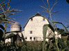
| We slept late for a change and enjoyed our continental breakfast at the motel. After breakfast, I photographed parts of the motel, Route 66 Rail Haven, because it is a historic Route 66 motel from the days when the Mother Road carried people between Chicago and Los Angeles. |
 Route 66 Rail Haven. |
| We spent the rest of the day with my wife’s family. We enjoyed lunch at Lambert’s Café in Ozark on Highway 65 between Springfield and Branson. This is a family style restaurant, “the home of the throwed rolls” because a man comes around pitching large rolls to diners. The restaurant serves country food with servers coming around offering additional sides which are included. We ate well and enjoyed the experience. |
 Throwing a roll at Lambert’s Café. |
| We got off about 5:00 AM heading north on Interstate 49, watched the sunrise over Harry S. Truman Lake, and passed through Kansas City which we really didn’t see from the highway, and switched to Interstate 35. I-35 took us into Iowa. We crossed the state line and were disappointed that there was no place from which we could photograph the “Welcome to Iowa” sign. Within a few seconds we were at the Welcome Center in Lamoni. |
 Welcome Center.
|
We continued to Madison County and stopped at Imes Bridge and Holliwell Bridge on the way into the town of Winterset. We spent a few minutes photographing the beautiful Courthouse and other parts of the town and getting a little information at the
 Holliwell Bridge. |
 Courthouse. |
| Visitor Center/Chamber of Commerce (73 Jefferson St.). The third bridge was Cutler-Donahoe Bridge in City Park and from here we proceeded to the far back of the park to see Clark Tower. Clark Tower is a stone tower about 25 feet high with a commanding view of Madison County to the south. The next bridge was a bridge to the past. The popular actor know as John Wayne was born in a little 4 room home in Winterset. Today the house has been restored although most of the furniture is not original. A small museum with |
 Cutler-Donahoe Bridge. |
 Clark Tower.  John Wayne Museum. |
many items relating to “The Duke” (as he was often referred) is adjacent with a large bronze of the actor in front. Roseman Bridge was the next bridge on our tour and one of the two used in the movie Bridges of Madison County. This was the only bridge with a gift shop and is considered to be the favorite. The other bridge used in the movie was next but there is a sad story connected to this one. It seems that last April, a 17-year-old man burned the bridge because he had carved his name and that of his girl friend into the bridge and they broke up and this seemed the best way to remove the initials. The entire county is upset and his trial was moved to another county. This was the only bridge allowing vehicular traffic, now it is chard. On the way out of town we drove past Hogback Bridge. There were once many more bridges in the county but it still has more than any other part of the state. We continued north to I-80 which we followed east to Des Moines. We followed our MapQuest direction to some place two miles west of the Capitol but managed to find the building anyway since it was so tall. Unfortunately we were a few |
| minutes too late to see the interior so we walked around the building with its scaffold covered dome. We did the best we could in a few minutes to see the exterior and the expanse of gardens to the west. By coincidence, the parking lot was used as a remote parking for the State Fair with free shuttles. I would have liked to have gone to the fair, but it had been a tiring day and we needed to move on. Next we headed back west a few miles. |
 Iowa State Capitol. |
| It wasn’t too hard to find Pappajohn Sculpture Park and street parking adjacent. My wife was tired and waited in the car as I spent about half an hour wandering the garden. Normally I would have noted the artists, but that information was in code read by smart phones which I wasn’t able to do, so all I can say is that I liked the large head the best. The park is at 1330 Grand Avenue. |
 Pappajohn Sculpture Park. |
 Historic Museum in Cedar Falls. |
It took about two hours more to reach our accommodations in Cedar Falls. After checking in, we headed to down town looking for some place to enjoy dinner. It took a while during which time I stopped for a quick minute to photograph the exterior of a historic museum that we wouldn’t have time to visit. Finally we discovered Chapala Family Mexican Restaurant (Corner of Hudson Road and Highway 57) and it was to our liking. We returned to our room and tried to recover from a very busy day. |
|
Day Four - Is This Heaven? No, Its Iowa | |
| We got up early (again), enjoyed continental breakfast, and checked out by 7:00. We headed east along US-20 to Gilbertville and attended Mass at Immaculate Conception Church, built in 1875. This a beautiful church like many others built about that time in the Midwest and it reminded me of the small town church in Minnesota where my Mother had attended. We were informed that the Dubuque Archdiocese was the oldest west of the Mississippi River. I like small towns |
 Veterans Memorial. |
| and on the way out, I photographed a small Veterans Memorial near the ball fields. We were on a tight schedule so we had to get back on the Interstate and leave this piece of Americana behind. | |
An hour or so later we were on a road used in the final scene of the movie Field of Dreams. The reason for this is that it leads to the location used for most of the movie. The house was real with a bay window added by the studio for some important scenes. Most of the ball field was on one farm with the house and other buildings but some of the corn fields were on an adjacent farm. Today, 194 acres have been purchased and there are plans to build a type of baseball camp. We had time before the house tour to wander through the corn fields and recall the movie. Although I work in the film industry and understand how things work, the
 Baseball field at Field of Dreams Movie Location.
tour was informative and interesting and we enjoyed it immensely. Our guide told of how there was a bad drought the year the film was shot so the studio had to provide extra water so the corn would grow. This caught my attention remembering the same summer I was a few hundred miles north and remember the drought. I asked if the snow was real because I use to do Special Effects and know how hard it would be to fake that much snow. It was real, they came back the following winter to do those scenes.
|
 Basilica of Saint Francis Xavier. |
The priest in Gilbetville suggested that we should see the cathedral in Dyersville while there, so we stopped for a few minutes to take a few photos of Basilica of Saint Francis Xavier. Mass was just starting so we only peaked in the door. We took a few photos of the town, got lunch and gas, and headed south. We actually backtracked about 15 miles west on US-20 to County Road 13 south. We continued south through Cedar Rapids and Iowa City and through what seemed like endless fields of corn and other crops. We drove through mile after mile of corn along IA13 and IA27/US218, among others, until eventually we crossed back into Missouri about 3:30, then headed south on US24/US61 and after a while, arrived in Hannibal about 4:30. I knew this trip was fast paced because of limited time, and I had only hoped to get to Hannibal in time to visit the Mark Twain related sites. The entire Mark Twain Boyhood Home and Museum complex would close in 30 minutes, so |
|
we had to rush through the Interpretive Center, Huck’s cabin, Mark Twain’s Boyhood Home, Becky Thatcher House, and J. M. Twain’s Justice of the Peace. We did it with not a minute to spare. Of course some of these are fictional characters, but based on real people who had lived in these homes. We completely skipped the Gallery because it was now closed. We checked into our hotel and rushed off to Mark Twain Cave for the 6:00 cave tour. The 6:00 P.M. tour had just filled, so we bought tickets for the 7:00 P.M. tour |
 Mark Twain Boyhood Home and Museum. |
 Mark Twain Memorial Lighthouse. | and returned to town. We climbed to the base of Mark Twain Memorial Lighthouse (at the top of Cardiff Hill) and unloaded at the hotel by which time we needed to return to the cave. I’ve been in many caves, but this was unique in being a maze cave and the coldest in the country. Most caves that I have been in are twisting with elevation changes with some branching corridors, rooms, and galleries and the spaces are sometimes large. This cave has many |
 Mark Twain Cave. |
|
straight parallel and perpendicular tunnels crossing almost like a grid. They are also narrow with many horizontal grooves carved by the water that dissolved the limestone. The corridors are high and it is also more level than most caves that I have visited and with natural glacial sediments on the floor rather than the paving of other tourist caves. We enjoyed dinner at Mark Twain Dinette which was across the street from our hotel. We were exhausted and fell asleep quickly. Day Five - Bring Back the Sun We got up about 5 and were on the road by 6:00. We got gas and headed west, well, we intended to head west. Once across the Mississippi River, we turned around and crossed back over. That was my second visit to Illinois, the first time 52 years earlier also lasted about five minutes. So finally we were headed in the right direction, for about two minutes. After proceeding a few miles I realized we had missed the turn but by this time I decided to continue and take a farm road south about 30 miles until it intersected Highway 19 further along the way. After that, things went smoothly along US 19 until we reached Jefferson City. I'm not sure where the printed directions went, but the capitol building is large and I found it on my own. | |
 Southeast end of the Capitol. |
 Missouri_State_Museum_Resource Hall. |
|
We needed to check in for our tour by 8:00 and it was now a few minutes to that time, so I dropped my wife off at the Capitol and parked two blocks away. By the time I reached the green before the Capitol, the festival was starting. My wife had already signed us up for the Capital tour so we could just relax now. We had about 45 minutes before the tour so we wandered the basement and first floor. The center of the two side wings of the first floor are the Missouri State Museum with numerous exhibits that I found interesting. | |
| The tour started and took us through the second, third, and fourth floors. The Senate Chamber was off-limits but we sat in the gallery of the House of Representatives. Throughout the building are many surfaces covered with murals and even the fire extinguisher cabinets were decorated. Once the tour was finished, we finished exploring on our own. My wife rested while I walked around to the back of the capitol and then on to the Louis and Clark statues and the Governor's Mansion. We |
 Governor's Mansion. |
| still had about two hours before the eclipse so I walked back to the car for my tripod (which I ended up not using) and then found my wife hiding in the shade on the back side of the stage. It was still quite hot and humid as the Sun slowly disappeared behind the Moon. | |
| This was my first total eclipse so I wasn’t sure what to expect. The Sun dimmed so slowly, even when the Sun was only a thin crescent only 20 minutes before totality, it seemed bright and the heat never let up. We had glasses we bought for the occasion, NASA was there handing out glasses, and I had my Griffith Observatory viewer that I had bought for a partial eclipse 25 years earlier. The capitol had predicted crowds of 50 to 100 thousand and while I am only guessing, it seemed more like 20 or 30 thousand. As the sun slowly disappeared, a band played the Darth |
 The front steps of the Capitol and the crowd waiting for the eclipse. |
| Vader March and other appropriate music. There were venders but unfortunately, none sold regular food, so my wife was a bit hungry. Everywhere there were cameras and telescopes on tripods, lawn chairs, and people enjoying the best natural show in 99 years. Finally about fifteen minutes before totality, I set my new GoPro video camera on a window sill and recorded the next twenty minutes. About five minutes before totality, it finally started to get noticeably darker as if when clouds suddenly cover the Sun. The crescent got thinner and thinner until it was only a dot and then the crowed cheered as the last speck of Sun vanished revealing a black velvet disk surrounded by the ring of the corona. I didn’t want to waste my time taking photos that I was sure wouldn’t be so great since I didn’t have the proper filter, so I just looked around, watched the other people, gazed at the illuminated distant horizon, listened to the cicadas, and looked at the Sun while it was safe to do so. After a short two and a half minutes, the Sun reappeared and we had to put our viewers back on. The band played Also sprach Zarathustra as the Sun reclaimed its realm. About five minutes after totality ended, I started packing up, turned off the GoPro and we hurried back to the car. | |
| We got out of town relatively quickly and the traffic was moderate (as least compared to Los Angeles). My wife still wanted lunch so we stopped for a sub sandwich, which was doing great business that afternoon, but by the time we got back on the highway, the people who packed up after us were now ahead of us and we were in the middle of a hundred mile long traffic jam. This part of rural Missouri isn’t used to this many cars all at once and traffic backed up several miles at every traffic light in the one-light towns that we passed |
 Traffic Jamb. |
|
through. It took longer to get back to Springfield than we had hoped but eventually we arrived, checked into the same motel we had left a few days earlier, and spent the rest of the evening with my wife’s family. Day Six - Stainless Steel Arch and Flying Aluminum
| |
|
We got up early (yet again) and were on our way back to Saint Louis. We reached Interstate 44 late because of construction and no clearly marked detour. Then about 20 minutes down the Interstate a major rain storm began suddenly, accompanied by some lightning. The rain continued for a bit less than three hours, easing toward the end. Eventually we found the Gateway Arch but the MapQuest directions again lead us astray and I parked further than I should have, just to park anywhere, and we walked several locks back to the Arch. We weren’t late, but we weren’t early either, so we skipped the exhibits at the Courthouse. The monument is undergoing a major reconstruction to the visitor center scheduled to be complete by 2015, the 50th anniversary of the Arch’s completion (I know, it’s 2017 and it’s still not finished). Ironically, the first time that I saw the arch was a few months before its completion and now I return and it’s under |
 Gateway Arch behind Basilica of Saint Louis.  Courthouse. |
|
construction again. Because of the construction, we had to walk the long way around to the south to enter the north tower. We lined up and eventually arrived at the lower tram loading. We felt like Mercury Astronauts with five people climbing into a small sphere. The tram assembly, which consists of about eight spheres, takes about 4 minutes to ascend to almost the top. Since the arch becomes thinner as it rises, the upper station was very cramped and also doesn’t quite make it to the top. The final assent to the observation room at the top is by stairs and then the curved floor of the inside of the top of the arch. At the top are two rows (one on either side) of low windows allowing a view out over Illinois to the east and Saint Louis and Missouri to the west. You can stay at the top as long as you want, but there are no facilities and after a while, you’ve seen enough and are ready to take the tram back down. We arrived at the bottom just in time for the movie about the construction of the arch which I found interesting. It was now time to hurry back to the car and get to the airport. The GPS wasn’t working, the rental car return wasn’t well marked and even when we were on the correct street, it became a freeway before we reached the address and it took some time and asking directions to find another disconnected section of the street and finally, frustrated, found it. After battling with the boarding pass machine, removing six pounds of stuff from the checked bag (even though we had removed some things and the only thing I added was a baseball cap for my brother), and walking to the end of the terminal with all the carry-ons, we finally arrived at Gate 28 of a terminal with 24 gates. Gates 27 and 28 are at the end of a long hall in a large room kept lock except for occasional use. Not wanting to drag my things back to gate 24, I sat on the floor by the closed door and explained to everyone as they too arrived confused, what was going on. Finally, an hour before departure time, the doors opened, and the hundred or so standing passengers could go inside and sit down. The over-booked flight pushed back on time and there was only a little turbulence in your three and a half hour flight. We landed on time, found our checked bag and the Flyaway bus. The bus was full before it reached the last two terminals so we were all pretty tight. We finally arrived home and our dog was so happy, the cats were mad. It took several weeks to download all my photos and longer to process them. We had driven about 1,700 miles in six days, touched in four states (including California where we started and Illinois when I missed the turn). My experience with modern day air travel was so bad that I vowed never to fly again. I called the airline ten months before the flight on the first day that reservations were available, paid what they asked, not some discount broker, no refunds allowed, they had my money for almost a year, and when we asked why we were so low priority, we were told that our tickets were restricted and they could not tell us what that meant. We were at the airport early and among the last to board. I’d gladly pay a little extra to not be treated like cattle. On the way back, I couldn’t get a window seat and the woman in the window seat never looked out the window at the beautiful scenery and she was the only one who needed to get up during the flight. |

|

|

|
| Note:This is not the official site for any of the places shown in Places Earth. Places Earth is not responsible for accuracy of the information. Hours of operations, prices, exhibits, and sometimes locations are subject to change without notice. |
|
Support this Web Site I hope that you find this web site helpful. It started because of my love for Architecture and interest in History and a desire to share my photographs and tales of my adventures. I don't allow paid advertising. This web site is for your benefit and enjoyment and I make no profit on it. For twenty years it has been supported primarily from my regular paycheck as a Set Designer. If you are in the need of a designer, please see my Set Designer portfolio site Set Design Portfolio. |
|
Links |

|
This site maintained by Kenneth A. Larson. Copyright © 2004 - 2023, Kenneth A. Larson. All Rights Reserved. Website content including photographic and graphic images may not be redistributed for use on another website. |

|

|

|