Places, Earth
Death Valley 2023
Death Valley 2023
|
|
Places, Earth
Death Valley 2023 |
|
|
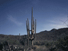
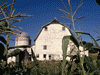
Introduction It had been many years since I last visited Death Valley and I wanted to see it one last time before my traveling days come to an end. Again my wife passed so I reluctantly went alone. I selected Death Valley for this MLK weekend because it is Death Valley and it doesn't rain there often. In the proceeding week, I closely watched the rain forecast as it vacillated between rain and sunny. I packed and loaded the car still wondering if I should go. My original plan was to stop at Trona Pinnacles and Ballarat on the way north, but because of the recent rains and the concern that the dirt roads to both locations would be muddy, I postponed those stops until a day trip in Spring. Day One, Getting There Saturday morning I said good bye to my wife, dogs, cats, and three adorable kittens, making sure none were in my office or garage. I few drops of rain fell on the windshield as I backed my twenty-two year old Sable station wagon out of the garage. I departed at 8:00 AM and headed north on Highway 14. There was a light rain off and on. At Mojave I made a right turn to stay on Highway 14 (easy to miss that one). The rain increased as I continued north out of Mojave. It had been a long time since I last came this way and I noticed many solar energy facilities in the desert, of course they work better when they aren't receiving the rare rain. Highway 14 passes through Red Rock Canyon State Park and I stopped a few minutes tophotograph the unusual rock formations in a gentle rain. An off and on rain continued as Itraveled north. At Highway 178 I turned right and again turned right in Ridgecrest, otherwise Iwould have ended up at China Lake Navel Weapons Center which would not have gone well with base security. I had planned to visit Maturango Museum but as I turned onto West Las Flores Avenue, I notice China Lake Museum just beyond with several aircraft and weapons in front. China Lake NWC is used to test missiles and bombs and training and this museum covers all of this. I stopped at this new museum for an hour before visiting Maturango Museum where I stayed another hour. Maturango Museum has exhibits on the Mojave Desert, China Lake NWC, the surrounding area, and offers tours to the petroglyphs on the base (temporarily suspended at the time of this writing). I then continued east. I crossed into San Bernardino County and passed the road to Trona Pinnacles, continued through the Town of Trona, crossed into Inyo County, and on to Panamint Valley. I passed a sign saying "Elevation 0 feet." There was heavy fog at the summit between Searles Valley and Panamint Valley, about 2,930 feet. I passed the road to Ballarat and stopped to photograph the historical markers. Ballarat is about three and a half dirt miles on. I glided through Panamint Valley, a wide open expanse the next valley over from Death Valley to the east. The towering Panamint Range rises between. At a fork, I chose Panamanian Valley Road, Wildrose Canyon Road being too rough (although I did drive that way many years earlier). I turned right onto 190 and climbed out of the Panamint Valley. The summit is just under 5,000 feet. From here it is a long downhill glide to the floor of Death Valley. Death Valley is the lowest dry (not under a lake) location in the United States. It is the driest and hottest location in the United States. Because it is so dry, surrounded by mountains, with little vegetation, the heat is trapped and radiated back to the ground. But this was January, it had just rained, and it was cold. Fortunately the frequent wind waited until I was packing up on my third day. Death Valley National Park is the largest National Park in the contiguous (outside Alaska) United States and the fifth largest in the United States. I stopped at Stovepipe Wells to get my park pass, then continued on. A short stop at Devil's Cornfield and then on to Furnace Creek where I found my accommodations. The previous time we visited Furnace Creek Ranch, it was a collection of rustic cabins. Today there are neat rows of cottages, two or four units each, and a complex of shops, restaurants, recreation, a small museum, and I think more accommodations. By the time I unloaded it was 4:30 and would be dark soon. I ate dinner and settled in. Day Two, I awoke about 4:00, listened to silence for half an hour, read another half hour, fell back asleep, and got up at 5:30. I ate breakfast in my room, got ready, and left for Zabriskie Point. Zabriskie Point is off Highway 190 a few miles east of Furnace Creek Inn and it only took about fifteen scenic minutes to reach it. It is a short hike to a fantastic view of multicolored layers of rock. I had been frustrated with my camera not functioning properly, even after having it repaired a few months earlier, maybe the rain confused the auto-focus. I loaded film in my old film camera and it had just enough power left in the batteries to load the film, then went dead. I climbed the low hill and did my best to photograph the vista. I needed to Zoom into a meeting at 9:00 AM, but the Internet was still down so given no choice, I continued on to Mesquite Flat Sand Dunes. I had visited the dunes three times before, but this time the sand was moist and easier to walk upon and I ventured deep into the dunes, further than I had before. I started in a direction where I saw no people so I was able to photograph without footprints. I followed some bicycle tracks so as not to violate new sand. I then headed to the second tallest dune, covered with people. The only taller dune was some distance off and I needed a restroom already, so I began the long walk back to the parking lot. I stopped back at my room to regroup and then off to Dantes View about eight uphill miles from Highway 190 near the eastern park entry. The road to Dantes view passed several mines, I think they are just outside the park boundaries. The road is winding and the last quarter mile is steep so trailers and long vehicles are prohibited. My Twenty-two year old station wagon had no trouble and took me to the top of the hill at 5,475 feet. The view was breathtaking with an almost 360 degree view to the east and west looking down onto most of Death Valley and Badwater almost 6,000 feet below. The temperature was 38 degree but fortunately, no wind. I enjoyed the view then headed back down. I stopped at the Visitor Center for two questions. I had noticed the road to Scotty's Castle was closed and was told the castle and the road suffered damage in a bad flood several years ago. Fortunately I have seen it several times before and it wasn't on my list for this trip. I also asked about Twenty Mule Team Canyon road but was told it might be too rough for my car. There are many interesting points of interest in Death Valley, but many are only suitable for high clearance four-wheel drive vehicles, which my station wagon isnt. Another quick stop at my room then on to Badwater.Badwater Basin is the lowest dry place in the United States at 282 feet below sea level, or almost 6,000 feet below Dantes View. At first I wasn't planning to stay long but I just started walking out about a mile. After a long walk I was standing in the salt flat, along with dozens of other people. The walk back seemed to take forever and I was hoping to get back before dark, yet more people were just starting out. On the drive back to Furnace Creek, I was surprised at the number of cars still entering Artist Drive and Natural Bridge as it got darker. I got gas at Furnace Creek and returned to my room where I ate dinner and started packing. Day Three, A Long Side Trip I awoke about 5:00 and started getting ready. My list of things to see had three more sights, one every close. Within Furnace Creek Ranch is The Borax Museum with a collection of old equipment, Twenty Mule Team wagons, a steam tractor named Old Dinah and a building that was closed. A man was prepared to do a demonstration of making arrowheads from flint. The day before while traveling to Badwater, I noticed cars parked at a narrow canyon. Today it was only a few miles back to Golden Canyon. Except for one small spot where it is required to climb natural stone steps, the rest of the one and a half mile trail is an easy, relatively smooth and only slightly up hill trail. I hiked the Trail a little over a mile before I ran out of time. At every turn there is another display of beautiful geology. Rocks of all colors in layers no longer level lined the Canyon walls. There were hard rocks protruding from softer sides. It is truly a geology lesson. I was out of time and turned around a half mile from the end. My last stop in Death Valley was Furnace Creek Inn, a historic hotel. Many years ago we had dinner here, today I took a quick look and a few photos and headed back to the Ranch. I finished packing, loaded, and checked out. The day before the weather was pleasant, but the wind was coming up as I loaded. I have never used the Highway 190 east entrance, so I chose to exit that way. I few drops of moisture fell on my windshield from a blue sky as I exited Death Valley National Park. That Transaxle error light returned, it had been quiet for my previous trip. Once out of the park, I entered an open vista. A few more drops of rain and a rainbow to my left. At the junction of Highways 190 and 127, I restarted my car and the Transaxle warning light went away. There isn't much at Death Valley Junction, today Amargosa Opera House and Amargosa Hotel are most of the town. I took a few photos and continued . I then proceeded east on State Line Road, entered Nevada (I didn't see a sign), and drove through Ash Meadows National Wildlife Refuge. Eventually I reached Pahrump, Nevada. I took a few photos of Pahrump Valley Museum in a light rain. The Museum is closed on Mondays and of course, this was Monday. A heavy rain lasted about fifteen minutes as I drove through Pahrump. I continued south on Highway 160 about 15 miles to Tecopa Road. Then about ten minutes to Cathedral Canyon Road, a somewhat rough road for another two miles. Note, the Maps ap on my phone announced, "You have arrived" about a quarter mile early in the middle of a flat open plane. There is no sign, just a spot beside the road. Cathedral Canyon is a gash in the Earth about one thousand feet long and maybe twenty feet deep, with a pedestal of rock about half way down, topped with a decapitated statue. (36d,00',40.56"N 115d,21'12.15"W) I stayed about five minutes and continued west on Tecopa Road having no idea where I was since the road it isn't on my map. I reentered California just before Noon, noted only by small sign indicating Inyo County. The highway name changed to Old Spanish Trail Historic Route. I drove a long way on a road not on my map, guided only by the Maps ap on my phone. Although the road was a mystery and not a super highway, had I stayed on Highway 160, I would have passed just south of Las Vegas and added several hours to my journey home. The road is scenic and I enjoyed the drive, just a little apprehensive not sure where the road went. Finally I reached the small Town of Tecopa and after a few more miles, reached California Highway 127 and back where I would have been two hours earlier had I not detoured to Pahrump. At 12:45 I crossed into San Bernardino County. In the distance I could see a sand cloud over a large dune complex, Dumont Dunes. Sand blew across Highway 127. I continued south. At Baker, I got gas, photographed the World's Tallest Thermometer, and entered Interstate 15 west. The thermometer is 134 feet tall, one foot for each degree of heat in Death Valley in July 1913. I was making progress until leaving Victorville when traffic slowed amid dense fog. Eventually I arrive home to my family including three adorable kittens. I had revisited a few sites at Death Valley, spent more time at some, and saw a few new sites. I don't think I had used the Highway 190 east entrance before or ventured to Pahrump. This may be my last visit, but unless I get access to a high clearance four-wheel drive vehicle, I couldn't see more new sights than I did. Till next time. |

|

|

|
| Note:This is not the official site for any of the places shown in Places Earth. Places Earth is not responsible for accuracy of the information. Hours of operations, prices, exhibits, and sometimes locations are subject to change without notice. |
|
Support this Web Site I hope that you find this web site helpful. It started because of my love for Architecture and interest in History and a desire to share my photographs and tales of my adventures. I don't allow paid advertising. This web site is for your benefit and enjoyment and I make no profit on it. For twenty years it has been supported primarily from my regular paycheck as a Set Designer. If you are in the need of a designer, please see my Set Designer portfolio site Set Design Portfolio. |
|
Links |

|
This site maintained by Kenneth A. Larson. Copyright © 2004 - 2023, Kenneth A. Larson. All Rights Reserved. Website content including photographic and graphic images may not be redistributed for use on another website. |

|

|

|