Places, Earth
Road Trip: Death Valley
Road Trip: Death Valley
|
|
Places, Earth
Road Trip: Death Valley |
|
|
Friday, April 14, 2006. It was Good Friday, a work holiday for myself and my wife, on top of that, I finished a job Wednesday, so I had no job anyway. My wife took Monday off and we left for a four day Easter trip to Death Valley - a holy day about resurrection celebrated at a valley named for death. We left Los Angeles about 7:30 am, behind schedule as usual. Driving north on California State Highway 14, it took about an hour to cross into Kern County. I got just a little off | |
| course when new highway construction had my usual route closed, so we backtracked a mile or two to just north of Mojave. Highway 14 passes through Red Rock Canyon, so we stopped to stretch our legs and take a few photos of the beautiful rock formations. We continued on Highway 14 until we reached California State Highway 178, the cut off to Inyokern and Ridgecreast. I like getting gas in Inyokern because I like the name of the town. |
 Red Rock Canyon in Kern County. |
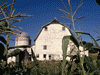
 Maturango Museum. |
In Ridgecrest, We stopped for about a half hour at Maturango Museum, AKA Death Valley Tourist Center. Maturango is a small museum, packed with information of the local deserts. The grounds are filled with rusty artifacts of earlier mining operations and civilizations as well as abstract metal sculpture and reproduction of Native American art. Inside are exhibits regarding the nearby Navel Air Weapons Station China Lake, the mineral mining around nearby Trona, native plants and animals, and Native American artifacts. |
|
From Ridgecrest, we continued east and then north through the historic mining town of Trona. John Searles had discovered various minerals in the dry lake that came to bear his name. The mining company passed through a long string of owners but is still producing a wealth of minerals. The town is less prosperous now than it was fifty years ago, but the community is proud of its heritage and history and operates the Guesthouse Museum, History House, Trona RR Museum. Trona lies on the northern edge of San Bernardino County and within minutes of driving through down town Trona, we crossed into Inyo County, the county containing most of Death Valley National Park. From Trona, the highway, Trona-Wildrose Road, slowly climbs in elevation to the summit, then winds its way to the floor of Panamint Valley. Panamint Valley is like a smaller version of Death Valley, just over the mountains to the east. The view as one begins the decent into the valley is breathtaking, but few seem to take notice of the wonders of this large basin. We couldn't resist taking a little dirt road a few miles east to the ghost town of Ballarat. Ballarat was a support town for miners in the Panamint Valley from about 1890 to the | |
| beginning of World War I. There are a half dozen or so collapsing, mostly wooden buildings scattered over several acres. The wooden jail looked like something one could escape from with one full body block, but the wood might have been more resistant when it was new. The caretaker informed us that the rusting old truck had once belonged to the infamous Charles Manson. I was more interested in the deteriorating wooden wagon a few feet beyond. We spent about an hour at Ballarat and then continued along our way. |
 The historic town of Ballarat. |
|
The highway continues north through Panamint Valley past the turn-off to Panamint Valley Road and into Death Valley National Park. After this junction with Panamint Valley Road, the road has been washed out several times and the Park has given up on trying to keep it paved, so there is an undeveloped section in the middle. So we took Panamint Valley Road until it ended at California State Highway 190, connecting U.S. Highway 395 to the heart of Death Valley. From here we drove east, up a steep approach, over the summit, and wound down a long alluvial fan to the floor of Death Valley, a few miles from Stovepipe Wells. Stovepipe Wells has lodging, gift shops, and food, but we had no need to stop so we continued on to our reserved lodgings at Furnace Creek Ranch, a half hour beyond. A short distance after Stovepipe Wells is the turnout for the Sand Dunes, the most | |
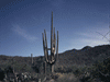
 Devil's Corn Field. |
popular and accessible of the half dozen or so dune systems in Death Valley National Park. We attended a sunrise Easter service at the dunes two days later. Not far after the Dune turnoff, on the right side, is Devil's Corn Field, so named for the odd plants here that reminded the early explorers of corn stalks. These vertical plants, averaging about four feet tall, resemble Joshua Trees, but not as tall and without branches. |
|
At this point, Highway 190 makes a right turn and heads southeast toward Furnace Creek. From this stretch, the geology of Death Valley becomes more apparent. Death Valley is not really a valley, valleys are usually cut by rivers. Death Valley is really a basin, formed millions of years ago when the surrounding mountains rose up due to tectonic forces as the basin floor dropped. The mountains eroded, filling the basin with an average of six hundred feet of sand and rock. As we dove southeast along Highway 190, it was easy to see every few miles along the base of the mountains where this material washed out of the canyons and out onto the basin, forming many alluvial fans, fan shaped deposits of these former mountains. Despite six hundred feet of this material, the basin has dropped so far, that much of Death Valley is below sea level. In wetter parts of the world, basins like this filll with water and it's less apparent, but with an average rainfall of about two inches a year, it has been a long time since Lake Manly dried up, leaving only the remnant we now call Bad Water. | |
|
About two miles before Furnace Creek are the ruins of Harmony Borax Works. This is where Death Valley began its commercial phase. Borax was hauled from this site in the famous 20-Mule Team wagons south to Mojave. We made a quick drive by before stopping at the Death Valley Visitor Center. I will return to Harmony Borax Works on Sunday. I stopped at the Visitor Center to pay my seven-day park fee of $20.00. We got more information of highway conditions, more |
 Harmony Borax Works. |
| places to visit, my wife bought some souvenir books, and we toured the small museum. Two minutes later, we were checking into our room at Furnace Creek Ranch. |
 Bad Water. | We partially unpacked and continued south to Bad Water, the lowest spot in the United States. There is a roadside parking area, interpretive platform, and board walk. The boardwalk transitions to a well worn trail out across the salt flat. I followed the trial until it ran out, photographed the panorama, and turned back. High on the mountain side 280 feet above is a sign saying "Sea Level." I did my best to steady the camera tripod in the high winds that persisted each afternoon that we were in Death Valley. I took a picture for a group of |
|
Asian girls and headed back to the car where my wife was already hiding from the wind. We headed back north to Highway 190 near Furnace Creek, then east to Zabriskie Point, stopping along the way to photograph some interesting rock formations. Zabriskie Point is a short distance off the highway and the parking lot is a short hike from the view point. Zabriskie Point is named for a borax mine superintendent and looks out over a panorama of rolling yellow hills back toward the northwest. It was getting close to sunset and we wanted to reach our next destination for sunset, so we continued along Highway 190 to Dante's View. Dante's View is one of the top tourist stops in Death Valley. The guide book says to come for sunrise, but sunset was the only time that fit our schedule. Dante's View looks out over the heart of Death Valley and the mountains beyond. There were a dozen or so cars when we arrived about fifteen minutes before sunset. It was mid April and warm but windy in the Valley. Here at Dante's View, it was cold and windy. I forgot to check my car's thermostat, but I'm guessing it was in the yjirties or forties. We watched the sunset and as it faded, the cars left one by one. It was ten minutes to dark when we left, trying to get back to the highway while we could still see the road. We enjoyed a nice ranch dinner at Furnace Creek Ranch and retired to our room. There are lodgings at Stovepipe Wells Village at Stovepipe Wells and Furnace Creek Inn and Furnace Creek Ranch at Furnace Creek. The rest of the accommodations are campgrounds. There are many places of lodging in the surrounding towns. Our room at the Ranch was a little two-unit cabin with bath, TV (which we never used), and a refrigerator. The Ranch has a small Borax Museum which we would visit on Sunday, a classroom where we celebrated an Easter Mass, a Post Office, laundry, the only general store in the Valley, and two restaurants and a bar. Just before we went to bed, I told my wife to go outside and look up at the sky. There are a few million more stars visible here than at home in Los Angeles. Saturday, April 15, 2006, Day 2. |
| I had been wanting to see Rhyolite Ghost Town for a long time, and that was the first of our two priorities for the second day. I started out heading south, then remembered I needed gas from the only gas station in the Valley so I turned around and returned north. After getting the gas, I again headed south a few miles before realizing I needed to turn around again and go north. We drove north to Daylight Pass Cutoff. Death Valley receives only a few inches of |
 Waiting for Road Maintenance. | |
| rain a year, but usually in a few large bursts. As a result, Daylight Pass was closed between the cutoff and the main road. The rest was undergoing repair. As we waited about fifteen minutes for a road construction worker to give us the "all clear" so we could proceed, I told her that at least the view was nicer than being stuck on a Los Angeles freeway. A small triangle of Death Valley lies in the state of Nevada, so we crossed the border into Nevada. This was the first time my wife had been in Nevada, so we stopped to pose by the "Welcome to Nevada" sign. About five minutes later, we left the park. | ||
 One of the several ruins in Rhyolite. | About ten minutes later we pulled onto the short road that took us to Rhyolite Ghost Town. Rhyolite is now a collection of mostly stone ruins. The Railroad Depot is mostly in tact, but closed and surrounded by a chain link fence. A grizzled caretaker gave a little presentation about various rocks in his collection. One was a "dog rock," the perfect size to throw at a dog and a common rock called leverite, "lev' 'er 'ite there." I can't explain the "sex rock" in a family article. In this park, you drive from one ruin to the next, and so we did. There |
| was the school house, a large stone buildings, now only about the bottom half remains. A short distance on was a cluster of a half dozen other stone ruins and the depot a quarter mile beyond. I drove down a terrible little road to one old building, only to find the other end of the road closed, It turned out both ends of the road were supposed to be closed and I should not have been on it. We drove around Rhyolite a bit more and headed out. On the way out, we stopped at Goldwell Open Air Museum, an open air contemporary sculpture garden, where my wife enjoyed posing with the sculptures. |
 The Last Supper at Goldwell Open Air Museum. |
| From Rhyolite, we continued a few more miles to Beatty where my wife lost 85 cents in her first experience with a slot machine. I dragged her away with her last nickle clutched in her hand. We drove north on US Highway 95 about an hour to Scotty's Junction. This was my wife's first experience with the wide open vista of Nevada. I pulled over to photograph a sad and lonely looking abandoned gas station of an earlier time. Scotty's Junction is nothing more than a road branching off the side of Highway 95. I half expected to see some buildings or something, but there was little besides a large open spot of paving. We turned left and headed back to Death Valley. |
 This gas station has seen better days.. |
| some buildings or something, but there was little besides a large open spot of paving. We turned left and headed back to Death Valley. | |
 Scotty's Castle. | We followed State Highway 267 southwest about a half hour, back toward Death Valley. We crossed from Nye County, Nevada into Esmeralda County, Nevada beside Bonnie Claire Dry Lake and then back into Death Valley as we crossed the state line back into California. Within minutes, we were at Scotty's Castle. What probably surprises visitors most about this Castle in the middle of no where, it that it's not Scotty's Castle. Walter Scott, AKA Death Valley Scotty, conned Chicago insurance man Albert Johnson into financing a non-existent mine. By the time |
| Albert realized he had been conned, he also realized that he enjoyed not only Scotty's company, but also the desert experience he discovered as Scotty dragged him around pretending to be showing Albert the mine. Scotty's Castle is really Albert's Castle. We bought our tickets and had about a half hour to look around before the tour. I climbed the hill behind the castle to see Scotty's grave, carved into solid rock. The wind was back and I scrambled down the hill side to retrive my hat which blew off several times. The tour lasted about an hour and began with our tour guide |
 Scotty's Castle. Courtyard. |
| telling us it was 1930. We were shown Scotty's room, where he actually didn't stay very often and various other rooms. Despite a grand and well planned beginning, the castle was | |
 Looking down on Scotty's Castle from Scotty's grave. | never finished because of financial problems and the slight miscalculation in location. It seems the land Johnson bought was actually a few miles northeast of the castle. The only thing wrong with the tour was it wasn't long enough. As we were about to leave, I observed some people coming out of the power house. When I inquired, I was told that this was the exit of the "other tour." We bought tickets for the underground tour for the following day as it was now too late for today. |
| From here we traveled about 20 minutes west to Ubehebe Crater, a half mile diameter hole left when a volcano exploded in geologic recent times. A 1000-year-old Little Ubehebe lies beside the big crater a half mile south. A trail circles both craters, but the wind was by now so strong and gusty, I was afraid to get too close to the edge. I was almost knocked over while trying to photograph the crater and being blow over the edge would probably have been fatal. We had dinner reservations at Furnace Creek Inn and had to race south for over an hour to make it. |
 Ubehebe Crater. |
|
After a mad dash across the desert and through a sand storm, literally, we arrived at the restaurant with 3 seconds to spare before our reservations - which they couldn't find. They were able to find us a nice table anyway and we enjoyed a wonderful dinner at Furnace Creek Inn - the only upscale eatery in the park. I again told my wife to look at the star-filled dessert night sky as we drove back to our cabin at Furnace Creek Ranch. We organized our thoughts and plans for tomorrow, now a bit rearranged by the underground Scotty's Castle tour we hadn't originally planned for tomorrow. Sunday, April 16, 2006, Day 3. |
 The Sand Dunes at dawn. | It was Easter and we got up early and rushed out and made the half hour drive north to the Sand Dunes for an Easter Sunrise Service in the Dunes. We had been told to look for the other cars and there they were. It was about a quarter mile walk out into the dunes where we arrived just as the service was about to start. The young minister was creative in making a connection between Easter and the beautiful setting for our service. As I listened, I tried to quietly photograph the rapidly changing shadows as the sun came |
| up over the dunes. After the service, we plunged a bit deeper into the dunes looking for animal tracks and pristine dunes, blown free of human tracks by the ever blowing sand. Fortunately, the high winds of the previous two afternoons were gone for now, but would return again this afternoon. | |
 Harmony Borax. | It was now breakfast time and we returned to our cabin for breakfast. My wife rested as I went out to photograph the old borax wagons at the entrance to Furnace Creek Ranch and the Harmony Borax Works ruins two miles north. The Harmony Borax Works processed borax from 1882 to 1889 and was the beginning of US Borax. The famous 20-Mule Teams hauled the borax over a 165 mile trail to Mojave. Two smaller ruins lie a few hundred feet northeast of the main ruins. An easy foot path takes visitors around the buildings. |
|
Another set of 20-Mule Team wagons sits beside the buildings. My wife and I toured the Borax Museum at Furnace Creek Ranch. Although a small building, there is an impressive collection of mining, ranching, and farming equipment behind the building. Even a locomotive and some shop buildings are seen in this back yard exhibit area. The exhibit building is only open November through April, 8 to 4 pm. |
 Borax Museum at Furnace Creek Ranch. |
| It was now time to make another mad dash north back to Scotty's Castle, or is it Albert's Castle? We arrive about 20 minutes before our tour which gave us a chance to see a few things we missed the day before. We gathered for our tour and were pleasantly surprised to find the same guide we had the day before for the indoor tour. I have spent many years building scenery for motion pictures and television and had managed to avoid wearing a hard hat. For the second time in my life, I placed a hard hat upon my hard head. The other time was for a similar tour of the Winchester Mystery House. The tour began above ground by the never completed pool, a pool so large Johnson had to call it a lake for legal reasons. We then entered a room that was to be the pool's changing area and later became servant's quarters. The tour included underground passages, including one that looked out into the pool from below the water level, piles and crates of unused tiles, miles of pipes, small water wheels to generate electricity for Mr. |
 Scotty's Castle. Basement Tour, corridor.  Boxes of unused tile seen in the Basement Tour. |
| Johnson's appliances, and finally to the power house for an explanation of how electricity was made from spring water. Overall, we were happy that we took the tour, although we would have preferred to have done both yesterday. | |
| Now back south an hour and a half to Natural Bridge, a canyon that looked to be out of a space movie with a natural arch about half way up. It was afternoon now and again the winds were screaming down the canyon, making it hard to walk on the rough canyon floor. It doesn't rain much in Death Valley, but when it does rain, large volumes of water and rock wash through these canyons, leaving alluvial fans at the outflow of every canyon surrounding the basin that is Death Valley. Getting to the parking area required driving the roughest |
 Natural Bridge. |
| road I attempted and walking on the canyon floor was also difficult, especially with the head wind. If you want to understand geology, visit Death Valley, it is filled with real life examples of what my text books wrote of. After the arch, I walked a few hundred feet more and could see that the canyon's beauty continued around the next bend, but my wife was waiting in the car so I turned around. The wind was at my back on the return and it went much faster. | |
 Artist Drive. | We next drove back north and turned at Artist Drive which is a loop passing Artists Palette. It may sound like I am repeating myself, but Artist Drive is lined with more beautiful rock formations in a rainbow of colors. The highlight is Artists Palette, a canyon filled with rocks of every color. Artist Drive is best in the late afternoon, but it was daylight savings time and would not get dark for another hour or two and it was dinner time. I was also almost out of digital camera memory, so we wrapped up and returned to Furnace Creek. We had |
|
dinner and began looking for the classroom. The classroom was way back but we finally found it just in time for another Easter Service. The priest travels the circuit of small area towns and finishes with an 8:30 pm service at Furnace Creek and spends the night . We retired for the night and got a good night sleep before our drive home. Monday, April 17, 2006, Day 4. | |
| The holiday weekend was over, my wife took an extra day off work, but had a college class at 4:00, so we got started early and began our drive home. We were almost done, we had a long list of sites we hadn't had time to see, or needed a 4-wheel drive vehicle to reach. I had wanted to see the Charcoal Kilns, but there was too much snow in Death Valley, or al least that part of Death Valley, and I didn't have chains for my car. We headed south along | |
| Badwater Road, passed Golden Canyon, something we hadn't had time to see, Artist Drive, Natural Bridge, and Badwater. We continued on a stretch of the rode we hadn't driven before. My wife doesn't like winding roads, and this way was gentler. The last stop in Death Valley was at Ashford Mills Ruins. The short lived mill was built in 1915 to process ore from a mine in the Black Mountains, but it never realized a profit and closed quickly. From here, we turned east and about 20 minutes later, left the park. |
 Ashford Mill. |
| At Shoshone, we caught State Highway 127 south. Off to the east we saw the Dumont Dune system. Unlike the sand dunes in Death Valley, the Dumont Dunes are an off-road vehicle wonderland and we shared the highway with dune buggies on trailers on their return trip from a 3-day weekend in the sand. After an hour on 127, we reached the town of Baker and got on Interstate 15, joining all the cars returning from a weekend of fun in Las Vegas. An hour more to Barstow and continued on California Highway 58 past the US Borax mine near the town of Boron. It was this large deposit, only about 30 miles from Mojave, that replaced the Harmony deposit in Death Valley. At Mojave, we got back on Highway 14 south and were home in plenty of time for my wife's class. We had missed a few sites for lack of time and had we driven a more rugged vehicle, we could have seen much more. Death Valley may be a dessert, but it is filled with life, beautiful and exotic scenery, and many natural wonders. |

|

|

|
| Note:This is not the official site for any of the places shown in Places Earth. Places Earth is not responsible for accuracy of the information. Hours of operations, prices, exhibits, and sometimes locations are subject to change without notice. |
|
Support this Web Site I hope that you find this web site helpful. It started because of my love for Architecture and interest in History and a desire to share my photographs and tales of my adventures. I don't allow paid advertising. This web site is for your benefit and enjoyment and I make no profit on it. For twenty years it has been supported primarily from my regular paycheck as a Set Designer. If you are in the need of a designer, please see my Set Designer portfolio site Set Design Portfolio. |
|
Links |

|
This site maintained by Kenneth A. Larson. Copyright © 2004 - 2023, Kenneth A. Larson. All Rights Reserved. Website content including photographic and graphic images may not be redistributed for use on another website. |

|

|

|