Places, Earth
Prescott to Sedona, Arizona
Prescott to Sedona, Arizona
|
|
Places, Earth
Prescott to Sedona, Arizona |
|
|
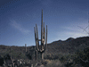
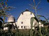
Day One - Getting There: We left about 8:30 AM and headed east to finish the trip we started last Christmas. Then we had cat trouble at home and weren't enjoying the trip worrying about our mother cat separated from her kittens, so we cut the last two days. Today the kittens were with their mother so we left them in the care of a pet sitter and departed, with apprehension. We considered a side trip to London Bridge but decided on the faster route. We traveled east on I-210 and I-10, stopping for a restroom break in Azuza and a rest area near Chiriaco Summit and got gas in Blythe. We crossed into Arizona about 12:30. Even had I not seen the sign, I would have known we were in Arizona from the Saguaro cactus that only live in the Sonoran Desert of Arizona. Shortly after, we turned north on US 60, followed it to State 71 and 89 along a winding road my wife did not like, eventually arriving at our hotel in Prescott. Many years earlier we spent a night in Prescott and visited the Sharlot Hall Museum, but today it was after 5:00 and we wanted to head out early tomorrow, so we spent a quiet evening watching Toy Story 4. Day Two - History: We enjoyed a quiet night, awoke about 4, got ready, and went to breakfast. We packed and checked out. We hadn't planned to spend much time in Prescott, but I took a few minutes to walk around the Yavapai County Courthouse before heading north. The Courthouse is surrounded with statuary and monuments which I photographed. It was only about thirty-five miles to Jerome, but the road is steep and winding and it took over an hour. Toward the bottom of the grade I stopped at a scenic overlook and realized the brakes had been overheating, so I tried to go easier the last few miles. A few minutes later we slowly wound through the town of Jerome clinging precariously to the hillside. The town has seen many landslides and fires over its history. Some buildings were rebuilt, most of brick, but many weren't. Jerome had been a prosperous copper mining town once, now it is mostly for tourist. A few minutes later we parked at Jerome State Historic Park. It is a single building, the former Douglas Mansion, now a state historic park. We wandered the exhibits, watched the video, and wondered some more. The second floor is smaller but had some interesting exhibits as well. Exhibits included models of the mines and history of the area. Outside are pieces of mining equipment and a blacksmith demonstration. It was only a few miles to Tuzigoot National Monument, former dwelling for people who moved on some centuries ago. The monument consists of a park building and partially restored stone dwellings. The stone walls climb the sides of small hill, the top of which allows a view of the surrounding landscape. After viewing the exhibits in the park building, my wife waited in the car while I climbed the hill. After arriving in Sedona, my plan had been to see the Chapel of the Holy Cross and then look for the McDonald's with the turquoise arches. This is believed to be the only McDonald's with turquoise arches because the city felt golden arches would clash with the style of the city. Suddenly I noticed the arches and decided to see them now before I lost track again. No chance of that, we passed them a half dozen more times. We posed next to a ground level sign and photographed a second set of arches on the upper facade of the building. We then went off looking for the chapel but never found it, so back to the Visitor Center where I found how to find the church but was told I couldn't go inside anyway, so we headed back the way we came to look for scenery. A left turn onto Upper Red Rock Loop Road lead to several views of red rocks in the distance. Back on State Route 89A we turned onto Airport Road. We drove up to the airport from which there is a popular view point. Finally we found our hotel just a few hundred feet from the Pink Jeep Tour check-in. After settling into our room, we walked along the rows of shop and restaurants to the Pink Jeep check-in. We asked questions about our tours the next day and wandered back to the hotel. We settled in, ate diner, watched a video, and tried to get a good night sleep. Day Three, Jeeps: Neither of us slept well and we arose early. Breakfast wasn't ready till 7:00 so we had plenty of time to wait, so we started getting ready. At breakfast, the news discussed the Annular Eclipse that morning. I know I brought my Griffith Observatory Eclipse Viewer home from our 2017 eclipse trip to Missouri, but I couldn't find it. We ate and continued getting ready. It was only a short walk to the Pink Jeep Tours Check-in and the hotel assured me I could leave the car there, so we packed up, checked out, and wandered back to the Pink Jeeps check-in. In a few places along the sidewalk we noticed projections of the eclipse on the ground through small gaps between leaves. Hundreds of small crescents, that would usually be round spots, covered the ground. In Sedona, we were half as far from the path of the eclipse as at home, so we saw more of the effect. We waited about 20 minutes, made a last restroom stop, and our pink jeep was ready. We had reserved two tours, the Broken Arrow/Rim Tour in the morning and the Anchent Ruins Tour in the afternoon. We received a short orientation and were off. The tour climbed some very rough and steep roads to the east and south of Sedona. There were several places where we got out of the jeep to walk around and take photos. The tour lasted three hours pointing out many points of interest and relaying lots of information about the history and flora and fauna of the area. Our driver/guide filled us with stories of other vehicles experiencing problems on these roads. Although the roads are rough through the National Forest, they are considered public roads and anyone can try to drive them, many shouldn't. After the first tour we had an hour to eat and regroup before the second tour. The second tour was a bit smoother but involved more hiking. It took about an hour to reach the Trailhead, about half on pavement. We hiked about an hour round trip along a loop trail with ruins of a settlement by two successive indigenous groups, the second group modifying abandoned ruins by the previous. The Return trip retraced the path coming in, but because of heavy traffic in town, it took a half hour longer than it should have. We returned to the hotel where we had left our car. We left Sedona at 5:30, a half hour behind schedule. I was hoping to reach Flagstaff before dark but we didn't make it. At least we were past the very winding section of the road before it got too dark and it wasn't completely dark by the time we reached Delhi Palace for diner. My friend says Delhi Palace has the best Indian food in the West. That may be true. This was our second visit and it was full with a thirty minute wait. I ordered Chicken Corma and my wife ordered Chicken Curry. Both were wonderful. We next departed, heading west to Williams. It took a little over half an hour to reach our hotel, the same place we stayed last December. We dragged in some of our things and settled off to sleep. Day Four, Home: We got ready, ate, and were on our way home by 7:20. We made a quick stop at Haviland Rest Area about 9:30, crossed back into California about 9:45, and stopped for gas in Needles. Then I decided to investigate the Harvey House for which I have often seen signs along the highway. It is a large railroad depot that seems to still serve AMTRAK. It was Sunday and seemed closed but a small sign on the door says it offers tours every day, but I think you need reservations. We stopped at two more rest areas between Needles and Barstow and then pushed for home, arriving about 3:20. The cat who we were so worried about last December did not take well to the pet sitter and it was a while before she started acting herself (which was still feral). |

|

|

|
| Note:This is not the official site for any of the places shown in Places Earth. Places Earth is not responsible for accuracy of the information. Hours of operations, prices, exhibits, and sometimes locations are subject to change without notice. |
|
Support this Web Site I hope that you find this web site helpful. It started because of my love for Architecture and interest in History and a desire to share my photographs and tales of my adventures. I don't allow paid advertising. This web site is for your benefit and enjoyment and I make no profit on it. For twenty years it has been supported primarily from my regular paycheck as a Set Designer. If you are in the need of a designer, please see my Set Designer portfolio site Set Design Portfolio. |
|
Links |

|
This site maintained by Kenneth A. Larson. Copyright © 2004 - 2023, Kenneth A. Larson. All Rights Reserved. Website content including photographic and graphic images may not be redistributed for use on another website. |

|

|

|