Places, Earth
Beyond Barstow, Amboy Crater to Mitchell Caverns
Beyond Barstow, Amboy Crater to Mitchell Caverns
|
|
Places, Earth
Beyond Barstow, Amboy Crater to Mitchell Caverns |
|
| It was February 2005, a nice time to visit the Mojave Desert. My friend, Kent, and I visited Amboy Crater. One day and a few weeks later, my wife, Joy, came along as the three of us visited Mitchell Caverns. Since these two sites can almost be crammed into a single day trip from Los Angeles, I decided to cram them into one Road Trip article. It would be better to make it a weekend. |
| Kent lives in Lucern Valley, about midway between Los Angeles and Amboy Crater. I drove solo about two hours before picking up Kent. From there, we traveled north along Barstow Road (Highway 247) to Barstow. There were record rains that year and normally dry lakes were temporarily spreading out across the desert creating reflection of mountains where there is usally sand. At Barstow, we turned east on Interstate 40 and traveled about an hour when we exited at Ludlow, a small forgotten town. We drove east on National Trails Highway for another half hour or so, traveling along a remnant of Old Route 66 toward the town of Amboy. This has became a forgotten section of the Mojave since the construction of the new highway. |
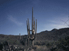
| We knew we were getting close to Amboy Crater when the sides of the road were covered with jagged pieces of basalt in all sorts of shapes and sizes. About ten minutes before reaching Amboy Crater, we passed another cinder cone which was not identified on my map. Then finally, we came over a rise and there in the distance was a large black cinder cone reaching into the blue Mojave sky. Actually, it was overcast, but the sky was blue when we drove past a few weeks later on the way to Mitchell Caverns. |
| We made a right turn and traveled a short distance south to the parking area. There is a sanitary station and a dispenser of literature at the side of the parking lot. A trail, or was it several discrete trails, headed off toward the cinder cone volcano. It's about a mile hike over rough terrain made largely of basaltic lava flows. It takes about half to three-quarters of an hour to hike each way, plus another hour or two to hike around, over, and into the crater. Allow two to three hours for the entire hike. |
| The 10,000 to 6,000 year old volcano is 250 feet high. Some brave souls climb up the front face, but most explorers trek around the right side to the breach in the west side. Here, the wall is about half the height and an easier slope. From here, we continued to the edge of the caldera. At this point, the caldera isn't very deep, but a trail heads off in both directions to the ridge above. |
| We began our climb up the trail, which is often littered with loose rocks and I had a hard time lugging my camera equipment to the top. There was several places where I was able to set up my tripod and take some beautiful panoramas. I also shot several stereo photos, unfortunately, a few weeks later, the stereo camera and much of my accessories were stolen with the film still in the camera. Somewhere out there, there might be a camera thief with my stereo images of Amboy Crater. |
| Finally we reached the top of the rim and looked out over many miles of the Mojave Desert. Off in the distance to the northeast was the small town of Amboy as a slight detail against the desert. Two thin lines crossed through the town and trailed off into the desert toward the east and west. One was the BNSF rail line, the other was Old Route 66. |
| It was about here that a rock played counter to all my bulky camera equipment and I went down, scratching my self and equipment on the jagged basalt. After nursing a few cuts and bruises, we continued around the other half of the ridge. Fortunately, the weather wasn't too hot and we traversed the remainder of the ridge of the cone with a big hole in the middle. |
| We descended back to the level of the caldera and explored it a bit before heading back out the breach. We were a bit hot and tired and the hike back to the parking lot seems a bit longer. Or maybe this was because the trail was less distinct and we probably cris-crossed a bit more. Eventually we made it back to the parking lot and shed our gear. |
| It was now about three in the afternoon and we started back. It was February and we were on Standard time and the shadows were getting long by the time we were driving south on Barstow Road. I'm not much for night driving, so I dropped Kent off and headed west into the darkness of the Mojave Desert toward home. |
| Three weeks later, Joy and I left early to pick up Kent in Lucern Valley. It is such a long way to Mitchell Caverns, I didn't even try for the first tour of the day at 10:00. We picked up Kent and again drove past the temporarily wet, dry lakes. We followed the same route as we had a few weeks earlier and when we reached Ludlow, I decided we were still too late for the first tour, but much early for the second tour at 1:30, so I took Old Route 66 again since Joy hadn't seen Amboy Crater yet. At the entrance to Amboy Crater, we stopped and posed next to the sign, something we forgot to do when we visited a few weeks before. This time, we drove on through the town of Amboy, a sad forgotten stop along a now almost forgotten highway. At Kelbaker Road, we cut back to Interstate 40 and continued east to Essex Road, the turn off to Mitchell Caverns. |
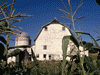
| Mitchell Caverns is within Providence Mountains State Recreation Area and still about 15 miles north of the highway. We followed the road as it started up the canyons and arrived at Mitchell Caverns, parked, bought our tickets (arrive early to be sure to get a ticket), toured the small Visitor Center / Museum, and unpacked our picnic lunch. It was the Mojave Desert, but late February and the weather was quite nice as we enjoyed our picnic in the adjacent picnic area. After killing some time, the tour guide finally called the tour group together and began the orientation. This is about when it finally occurred to me that I was about to enter a dark cave wearing my sunglasses and my regular glasses were in the car, so I hurried off to get them. Kent and Joy filled me in on what I missed and the group began the short hike to the cave entrance. |
| The half mile hike to the cave was by itself interesting and picturesque as it wound around the cliff side and past some interesting rock formations and smaller cave openings. The view south into the desert extended many miles to the distant mountains. Finally we reached the opening to the first cave. Mitchell Caverns are really three separate caves. Jack Mitchell, the first owner of the caves, named them "El Pakiva," or the Devil's House; "Tecopa, " named for one of the last chiefs of the Shoshone Indians; and "Winding Stair Cave," a deep and vertical cave too dangerous to allow public access. Jack had always wanted to connect the three caves to improve the tour, but lacked funds to accomplish this feat. After his death, the State connected the caves with a tunnel including an air lock to prevent changing the different atmospheres in the various caves. |
|
One by one we filed into the cave, a first for Joy. The tour began in EL Pakiva as we worked our way through the approximately half mile of passages. The caves were created in a wetter time and are now showing signs of dying. Decorations, a caver term for the stalagmites, stalactites, columns, and other limestone features in cave, are flaking off the walls of Tocopa. We climbed up and down stairs and squeezed through some tight passages - which was hard to do with all my camera gear. When we reached the airlock between the two caves, the guide waited until everyone was in the tunnel and the back door to El Pakiva was closed before he could open the front door and enter Tocopa. Tocopa is smaller, or at least the tour was, and as stated earlier, is losing some decoration. Here, the guild wrapped up his lecture and we climbed back into the Mojave sunshine. |
| The return hike was more freestyle and the group trickled back to the parking lot. |
| We returned west on Interstate 40 until we exited at Ludlow. This time we drove west on the Old Route 66 about 15 minutes to Pisgah Crater. This is a cinder cone volcano like Amboy Crater, but this one is slowly being mined for decorative rock as you might use in landscaping. Access is limited although the mine looked closed. Around back, a bit further than we were prepared to hike, are lava tubes. |
| It was well past dark when we arrived back in Lucern Valley. Kent was feeling isolated since moving to Lucern and we stayed to have dinner with him in a local restaurant. Kent was gracious to let us spend the night, but disappointed that we had to leave so early the next morning because Joy and I both had commitments Sunday morning. Joy and I slipped out the next morning before light and drove west, looking back from time to time to see a beautiful sunrise over the Mojave Desert. |

|

|

|
| Note:This is not the official site for any of the places shown in Places Earth. Places Earth is not responsible for accuracy of the information. Hours of operations, prices, exhibits, and sometimes locations are subject to change without notice. |
|
Support this Web Site I hope that you find this web site helpful. It started because of my love for Architecture and interest in History and a desire to share my photographs and tales of my adventures. I don't allow paid advertising. This web site is for your benefit and enjoyment and I make no profit on it. For twenty years it has been supported primarily from my regular paycheck as a Set Designer. If you are in the need of a designer, please see my Set Designer portfolio site Set Design Portfolio. |
|
Links |

|
This site maintained by Kenneth A. Larson. Copyright © 2004 - 2023, Kenneth A. Larson. All Rights Reserved. Website content including photographic and graphic images may not be redistributed for use on another website. |

|

|

|