Places, Earth
Beautiful Utah
Beautiful Utah
|
|
Places, Earth
Beautiful Utah |
|
| I had the crazy idea that we would leave about four in the morning. By 6:15 we were on our way. We headed north from Los Angeles on Highway 14, turning east onto the Pearblossom Highway. There was no real reason to take the Pearblossom Highway. My father always took it, but that was probably before the newly completed highways. Still, there are several points of interest along the route such as Charlie Brown Farm, Devil's Punchbowl, and a million Joshua Trees. At Victorville, we caught Interstate 15 north and continued through Barstow, stopped for gas at Baker, and crossed into Nevada. My wife was driving through Las Vegas and I shot photos of all the big casinos from the car like a big game hunter. We continued north through Clark County to the Arizona border. |
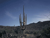
| Highway 15 passes through a small corner of Arizona and we continued toward a mountain. I wondered how we were going to travers this vertical wall with no obvious canyons and then we entered Virgin River Gorge, a deep, narrow, and winding natural cut through the mountain. We stopped a time or two to photograph the gorge and the river that cut it. It was the first introduction to the beautiful rock formations that we would be seeing over the next ten days. The passage through Arizona took only about 45 minutes and we passed through only one town, Littlefield, before entering Utah. |
| It was only a short time before we stopped for gas in Saint George, the first big town in Utah, and then headed east on Highway 9. We passed through a few small towns before parking in Springdale and taking the Zion Shuttle into Zion National Park. We stopped briefly at the Visitor Center, bought a year pass to all the national parks, and took the Valley shuttle to the end of the canyon and began the approximate one mile River Walk trail. The path was paved and mostly level and allowed some spectacular views of the rock formations and the river. At the end, there was an observation area and signs to describe that when the river is running lower and slower, hiking beyond is allowed. But the river was flowing fast and for now, this was the end of the trail. So we turned around and headed back. We next took the shuttle back one stop to Big Bend, just a spot with good views. We caught the next shuttle and got off at Weeping Rock. I took the 1/4 mile, very steep hike while my wife rested by the shuttle stop. At the end of the trail is a boundary between two rock layers where the more porous overlying sandstone meets a less porous sandstone and water seeping down turns to the side to emerge from the side of the cliff. I had to dodge water dripping on my camera as I photographed the spot. Next we continued with the shuttle to Emerald Pool which is an approximate 3 mile loop, but I walked only to the lower pool and back which as a bit over a mile. My wife stayed behind for this one too and photographed cottonwood fluff covering the ground like snow. A short stop at Court of the Patriarchs, the bus slowed for a couple of wild turkeys crossing the road - the male showing us a full Thanksgiving turkey display (why did the turkey cross the road?), and then we headed out, stopping to photograph a rising moon over the canyon rim. Sunset came an hour earlier than I had expected because I forgot that we had entered the Mountain Time Zone. |
| It took about an hour to reach our motel in Cedar City and we had dinner and drifted off to sleep, at least my wife did. I spent two hours working on digital camera problems - how nice it is to be rid of film with its "toss it in a bag till we get home" ease. |
| We attended mass at Christ the King, a beautiful newly completed church in Cedar City and then headed north. |
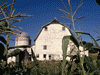
| I saw a small sign for Cove Fort along the highway between Beaver and Filmore and we decided to visit it. We were met by two missionaries who showed us around and educated us about the Mormon religion. The fort, built in 1867 of volcanic rock, is a collection of both original and restored buildings from the early days of Mormon occupation of the area. The fort was very secure but the gun ports were never needed, because Ira Hinckley, who ran the place, got along well with the Native Americans who considered him an honest trader. The settlement used oxen as beasts of bourdon and the barn contained some of the old harnesses. There is a blacksmith shop, a hay crane, a vegetable garden, and other structures. As we left, the missionaries gave us a simple toy, a wood disk in the center of a string. When wound and the stings pulled in opposite directions, the disk spun and it made a demonstration of how things work better when we "pull together." We weren't ready to convert to their church, but appreciated the lessons they taught us. |
| It took another half hour to reach the town of Fillmore where we observed the first state capitol, established 1851 and constructed 1852. Brigham Young felt that this central location would make a good spot for the capital and a building was begun. The decision was later made (1856) to establish the capital in Salt Lake City and the capitol at Fillmore was never completed but the south wing was used for county court and offices. It was restored in 1928 and is open for tours, but not the day we visited. The original capitol sits in quiet Territorial Statehouse State Park along with other historic and municipal buildings such as an early school and current courthouse. |
| We continued north through Salt Lake City where we could easily see the second (current) capitol from the freeway, but we didn't stop today, that would be tomorrow. Our motel was in North Salt Lake city where we checked in, and had dinner. |
| I had asked the desk clerk at the motel where was a good place to see the lake and followed the suggestion to Antelope Island State Park. A five mile causeway connects the mainland to this 28,022 acre island wilderness. The Visitor Center closed at 6:00 and it was now 6:30 so we just enjoyed the view. In several places, there were bison sculptures reminiscent of those we once saw in Catalina and the island supports about 500 live bison. The island is about 15 miles long and about ten miles down the east side, at the end of the road, is the Fielding Garr Ranch. According to the sign, the ranch should also have been closed, but was still open. We wandered through the buildings and grounds for about a half hour and returned to the north end of the island. We found a high observation point and finally drove to the beach to watch the sunset over the Great Salt Lake. The lake is so salty, only two animals can live in it, brine shrimp and brine flies. There were a couple of places where the brine flies were thick around us biting, but we got our revenge later. It is not legal to take anything away from a state park, but the rangers didn't seem to mind when we took a few thousand brine flies with us, plastered all over the front of the car. We cleared the gate a few minutes before lock-up which is a half hour after sunset. |
 My front bumper the following morning, covered with brine flies. |
| We returned to our motel and settled in. I was up late again trying to download my digital photos. |
| Monday started early, after a stop at a camera store, as we started by walking by the Governor's Mansion. The mansion is only open for tours during the summer season and then only on certain days, so we had to look from outside the fence. The mansion was built in 1902 as a private residence and became the home to Utah governors in 1937. In 1957 a new mansion became the governor's mansion until this one once again became the governor's home in 1980. Fire in 1993 caused a temporary evacuation but it was quickly restored and is still in use today. Address: 603 E. South Temple, Salt Lake City |
| Next we drove to the capitol. We parked and began by visiting The White Chapel, a 1980 reproduction of an 1883 building and next to it, the Travel Council Building, a tourist information center that was moved to this location and restored in 1963. Here we got even more ideas for our next trip. The newly reopened State Capitol was almost completely restored and once again conducts guided tours. Final restorations were still going on but our guide took us to all the important areas. Old and new art and statuary were about, some still not yet placed. The capitol was designed in 1912 and completed in 1916. Utah's capitol does not place the assembly and senators at opposite ends of the building as so many capitols do, instead, these two branches are adjacent to each other so that they can work together rather than oppose. Also the state's legislators are citizen legislators working only about 45 days a year for a token pay. Both of these factors, we hope, lead to better lawmaking. The interior rotunda contains the largest single piece marble columns in the county, made of Georgia marble, most of the rest of the marble is Utah marble. |
| It was not far to Temple Square, but down hill and we worried about walking back up once we were tired out from walking, so we moved a few blocks to a lot adjacent to the temple. First we took the advice offered by a guide book and visited the observation level of the Church Office Building. This offered a view in all directions of the entire Salt Lake City area, and our guide showed us the canyons that were important in Salt Lake City development and important buildings and land marks. Way off to the west was a tall smoke stack of a mineral processor and the airport with the lake beyond. |
| Back at ground level, we wandered the site, observing the beautiful gardens and historic buildings such as the Beehive House and Lion House. I had just finished composing a photo of a fountain with the temple behind and was about to click the shutter when the fountain was suddenly turned off. Disappointed I settled for Eagle Gate, a 76 foot arch over State Street at the corner of South Temple with a 4,000 pound bronze colored eagle on top. We stopped at the Temple Square North Visitor Center to see sculpture, paintings, and other displays to help tell the Mormon story. The tabernacle was once used for services, but those are now held in the Conference Center across the street and the famous Mormon Tabernacle Choir now performs here. One of the attendants demonstrated the phenomenal acoustics by tearing a piece of paper and dropping pebbles into a cup which were easily heard throughout this large elliptical domed buildings. We were running late and moved quickly through the rest of the complex and back to the car. We had to skip a large number of the stops and sites we had hoped to see and so hope to return in another trip. |
| It had been a hot day with predictions of cold tomorrow with an incoming storm so we were glad to be moving on. We didn't know yet that we hadn't escaped this storm. |
| We continued north on I-15 for about an hour to just north of Brigham City, taking exit 365 and driving west on Highways 13 and 83 (following the signs) another half hour through quiet peaceful countryside and views of the north shore of the Great Salt Lake to Promontory and Golden Spike National Historic Site. At last we arrived at the Visitor Center at the site where, on May 10, 1869, the Golden Spike (actually 2 golden spikes, a gold and silver plated iron spike, and a silver spike) was driven into a California Laurelwood tie to complete the first transcontinental railroad connecting the eastern United States to California and the Pacific Coast. Behind the Visitor Center were the two reproduction locomotives posed on the track. The Union Pacific locomotive 119 burned coal, the Central Pacific locomotive 60, better known as Jupiter, burned wood because there wasn't much coal in California. During operating hours, the two locomotives are displayed on the track, but at night, they are locked away in a barn a short distance off. About 4:00 pm, they are fired up and one at a time, run through some maneuvers and then drive off to the barn. The old steam locomotives used about 1,500 gallons of water to make steam to travel about 20 miles. This is why there were so many picturesque water towers built along the tracks. There isn't much water in the area, so it had to be brought in by trains. The locomotives also used a lot of coal or wood which also had to be brought in and stations, like the one at Promontory, were built about 20 miles apart. |
| From here we had a long drive ahead of us to reach our next reservation in Vernal, Utah. We headed back toward Ogdan and then on Interstate 84 and Interstate 80 until we caught Highway 40 east. Along much of this, there was road construction. What I noticed is that the cement mixers are all backwards to the ones I am so familiar with in California. In California, the big part of the cement mixer is in front and the smaller end that the concrete comes out of is at the rear top. In Utah, the small end is over the cab and I kept thinking they were driving backwards. It was a scenic drive, but the light was fading and the clock was racing and we could only afford a few quick stops. One summit we crossed was 6,020 feet in elevation with patchy snow. We crossed into Wasatch County and viewed the Strawberry River and watched the sunset over Strawberry Reservoir. It was getting dark as we crossed into Duchesne County and finally entered Uintah County. We were barely keeping our eyes open when we finally reacher Vernal and our accommodations at Dinosaur Inn. My wife settled off to sleep and I fought with the camera again. |
 Cement mixer in Utah. 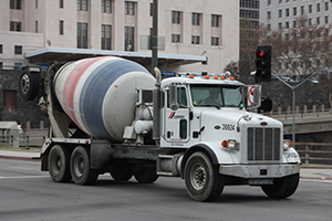 Cement mixer in Los Angeles. |
| We began our day early with a two block drive to the Utah Field House of Natural History State Park Museum which is a wonderful museum dedicated to prehistoric plants and animals, both dinosaurs and mammals. In addition to some excellent indoor exhibits, there is a short film and an outdoor exhibit called the Dinosaur Garden filled with full size replicas of dinosaurs and other prehistoric animals. I also took advantage of the gift shop to add a few more plastic dinosaurs to my collection. Address: 496 East Main (Highway 40); Vernal, Utah. |
| Next we drove three blocks to the Western Heritage Museum which had the usual collection of old equipment and other artifacts of household items. The museum sits within what looks like a performing arts park with an outdoor theater and a large building for presentations. The site was under renovation but the museum remained open and we took an hour to wander through it while staff attended to a school group. Address: 300 East 200 South; Vernal, UT 84078. |
| We now packed up and headed to Dinosaur National Monument. There are two main driving paths and numerous hiking paths. I've often seen photos of a large building constructed over the side of a cliff with a dinosaur skeleton still encased in the original rock. Unfortunately, this building is closed for several years for major structural repairs so we hope to revisit in about three years. The only dinosaur I saw in Dinosaur National Monument was a full size model of a Stegosaurus outside the Visitor Center. We bought two guide books, one for each of the two main roads, and began driving the western road which took us about two hours back into the park. We didn't see dinosaurs, but we did see beautiful scenery, petroglyphs by the people who lived here many years ago, and Josie's Cabin, the ranch of the last homesteader in these parts. We then drove east to the town of Dinosaur, Colorado, where, after a quick visit to the Welcome Center, we dove a few miles east of the Utah/Colorado border and onto the road that leads to the center of the park. We drove back into the park for about an hour. Again there we no dinosaurs, but beautiful scenery. Unfortunately, the goosenecks that I hoped to see at the end of the road required a long hike which we simply didn't have time for. So back we drove to the main road. |
| As I stopped for gas in Dinosaur, another customer warned me to be careful, that my car would go much faster with the new $4.00 gas. He was kidding of course as the $4.00 gas was the same as last year's $3.00 gas. Both the town of Vernal on the west side and Dinosaur on the east have many large models of dinosaurs, some standing around and some holding signs. It was a fun stop, but time to move on. We headed south on Highway 64 and then 139 through a bit of eastern Colorado scenery on a slow winding mountain road. Near Loma we caught Interstate 70 west and returned to Utah. |
| I exited and drove through the small town of Cisco and then onto Highway 128 across the desert toward Moab. This highway cuts through some of the most spectacular scenery in Utah but isn't well known. I had driven it 20 years earlier with my Father and brother on a cross-country trip to Minnesota and remembered the beauty, but now the light was fading and it was getting late. |
| We finally reached Moab a little after 9:00 and settled in for the night. |
| Moab is a nice little town that caters to tourists visiting Arches National Park, Canyonlands National Park, Dead Horse Point State Park, and the other surrounding sites and parks. There are all sorts of ATV rentals, jeep excursions, and even an aerial tramway to the top of one of the cliffs. Moab is one of the larger towns in the area and had most of the services we needed. |
| I got up at 5:00 and headed back the way we had come the night before, only now the sun was rising and it was getting lighter. I drove back as far as the Dewey Bridge across the Colorado River before turning around. The Dewey Bridge, built in 1916, had been restored in 2000 and clearly had since been severely damaged by a fire. Burned trees surrounded the south end and what looked like a wooden roadbed was now only metal and charred cable hanging from the main suspension cable. I thought of the people who probably worked so hard for the restoration that was lost in the fire. After a few minutes at the bridge, I returned to the motel, stopping quite often to capture the images of more spectacular scenes. While the Colorado River Recreation Area is not well known, the scenery rivals other better known areas of Utah. |
| By the time I got back, ate, and we did several errands, it was 10:00. Moab is only about 10 miles from Arches National Park and within minutes, we were climbing the steep road on the side of the cliff to gain access to the park's interior. We stopped a few times along the way to marvel and to photograph the pinnacles, walls, balanced rocks, and of course arches, all made of entrada sandstone. We started by driving to the end of the road with the plan to slowly work our way back to the park entry. |
| We put on sun block, I debated wearing a long sleeve sweater to protect my arms and decided it was too hot, and headed out along the trail. Within about 10 minutes we heard the clap of thunder and a gentle rain began falling, fallowed by wind and blowing sand. I made it to Tunnel Arch, Pine Tree Arch, and just far enough to see Scenic Arch before turning back. I stopped short of Wall Arch, after all, it will still be there next time. Two months later, Wall Arch made the news when it collapsed. On the way back, I found my wife still trying to get sand out of her contacts. From then on, we only did short hikes or observed that scenery that could be seen from the car. My wife waited in the car as I hiked the short distance to another arch, reaching it just as it started to rain again. The storm we had missed in Salt Lake City had finally caught up with us. |
| We finally gave up on Arches vowing to try to return a few days later if we had time and if the weather improved. As we finally cleared the front gate, the weather had improved so we went on to Dead Horse Point State Park where we were presented with grand vistas of the Colorado River snaking through goose necks far below. When we learned of the story of the name of this park, it made us sad. It seems that the natural shape of the canyon allowed cowboys to trap a heard of wild horses. They chose the best horses to break and use as cattle ponies, and left the rest, trapped, to die of thirst within sight of the river. |
| Dead horse Point is adjacent to Canyonlands National Park, a relatively new park established in the mid 1960. It took only about 20 minutes to drive from the Visitor Center of Dead Horse Point to the Visitor Center of Canyonlands. It was now getting late and we drove to the end of the long road, stopping to view and photograph the canyons, and then drove the other road to its end. The first road looked similar to Dead Horse Point, the second road very different, but hard to see in the fading light of an overcast sky. As we were leaving Canyonlands, we were entertained by a trio of young caves jumping and playing beside the road. See saw a lot of cows on this trip, many of them caves. We played hide and seek with the rain while in Canyonlands and we drove south toward Monticello amid often very hard rain. About midway, we passed Wilson Arch which is easily seen from the road - there is something to see everywhere. |
| It continued raining off and on all night and we awoke in the morning to find snow covering our car. The weather forecast was for rain for the rest of our trip, so we made adjustments to somehow get through |
| We left about 8:00 for Mesa Verde National Park in southwest Colorado which I had seen 43 years earlier. It took only about an hour to reach the park, but then another half hour to reach the Chapin Mesa Loop from which most of the cliff dwellings can be seen. There are two basic types of dwellings, those on and partly below the surface, and the cliff dwellings build into the side of the sandstone cliffs under overhangs. There was a second road (Wetherill Mesa) to more dwellings, but it would not open until the following week and we were almost done with the first and were debating whether I should do one of the longer hikes while my wife waited in the car. Then the decision was made for us. First, there was the clap of thunder, about five minutes later it started to rain, then hail, then sleet, then snow. It was only my second experience driving in snow and the first time in my own car. Visibility was only a few hundred feet and I had a small concern about icy curving cliff hugging roads, but the roads still retained enough heat to melt the snow on contact. |
| We left Mesa Verde just as it was clearing again and headed southwest. It wasn't long before we passed into New Mexico and the Navajo reservation. It was only a few seconds more before we reached our next stop, Four Corners Monument. Three quarters of the site is on Navajo land and it was a bit more commercial than I remembered from 1965, with stands selling Navajo jewelry and other souvenirs. There is a large concrete platform at the intersection of Arizona, Colorado, New Mexico, and Utah, with an elevated wooden platform at one corner from which to take photos. Everyone lined up to get a picture of themselves standing in four states at one time - the only place you can do this. I also photographed all four borders before moving on. My wife had grudgingly allowed me this stop, but I think she enjoyed it even more than I did. |
| Back on the road, it was only a few more seconds before we crossed into Arizona. Had we not stopped, we probably would have spent only about a minute in New Mexico, but we hope to visit that state in depth in two years. We had planned a major trip to Arizona for this spring, but had to cancel that trip and quickly substituted Utah. Check back next year. |
| We drove through northeast Arizona for about an hour before reentering Utah, still on Navajo land. A half hour later, we crossed the San Juan River which is the northern border of the Navajo Reservation. We continued north on Highway 191 through Bluff and Blanding to Monticello getting in slightly earlier than we had most nights of this trip. |
| We awoke to falling snow. The car was once again covered with the white stuff but it fell off quickly once we started driving. We discussed our plans considering the snow and even considered driving home today. We decided it was too far to make it home before dark and couldn't change our next motel reservations to a day earlier, so we made do. We came up with some rainy day plans, such as the museums in Blanding, then decided to see what we could of the southern section of Canyonlands National Park. We turned west onto Highway 211, stopping a few minutes at Newspaper Rock National Historical Site which is a rock face covered with desert varnish into which are carved many petroglyphs. It rained off and on while at Canyonlands, but this also allowed some rain and running water photos. We drove a dirt road about three quarters of the way back to the scenic spot, but were stopped by a raising river. I'm not sure about the two cars on the other side which had probably crossed before the rain started. I hiked a short trail past "Cowboy Caves" and somehow managed to drop my umbrella without notice (since it wasn't raining at the time) along this rough trail. My wife had turned back at the first of two rustic wooden ladders and it's just a well as the trail got rougher as I went. We had stayed longer than anticipated and in early afternoon, headed back south. It was a half hour dive back to Highway 191 through ranch lands and more scenery, and more cows. |
| We drove back to the Blanding Visitor Center and discussed the museums there since it was poring rain again, but then the sun came out and we made a mad dash for Monument Valley Tribal Park. We passed a very odd looking rock off the side of the road. I had photographed it twenty years earlier, but didn't know its name. This large flat rock looks like a crane placed it atop a thin pedestal, but it's natural and has been given the name Mexican Hat, although it doesn't look like one to me. A few miles on is the town of Mexican Hat where my wife bought one of the best Chicken Ranch Wraps she had ever had from K&C Store / Kokopelli Inn (although when I got home and filed my receipts, they charged me for two). It rained off and on during the drive south, but cleared by the time we arrived. I made a quick side trip to Gouldings Store to buy a replacement umbrella in case we needed one (then I found three umbrellas under the car seat the next day). Gouldings is more than a store, it is a resort with lodgings, shops, stores, gas, and food. It is across the highway from Monument Valley Tribal Park seemingly in the middle of nowhere. |
| We finally arrived at Monument Valley Tribal Park (think of it as equivalent to a National Park, only on Navajo land). We paid our fee, received our guide map, and began our adventure. Be warned that the dirt roads are among the worst that I've driven and the recent rains hadn't helped, however they got better the further in from the entrance. We were now in northern Arizona, Monument Valley straddles the Arizona-Utah border, but the entrance is in Utah and the loop we were driving was in Arizona. We spent about two hours driving through yet more spectacular scenery that Director John Ford used as backdrops for many of his westerns. The sandstone here is mostly butte, cliffs, and some spires. The park stays open until 8:30 this time of year, and we easily completed the loop in time to get back to Bluff in time for dinner. |
| On the way back, we again drove through Mexican Hat and passed the Valley of the Gods, described as similar to Monument Valley, but less cost. We had dinner at Twin Rocks Café, so named for the odd configuration of two rocks on the cliff behind. We enjoyed our dinner, strolled through the gift shop, and continued north, back to Monticello. |
| We awoke to our third morning of snow, but it was already sluffing off the car. We had spent three nights in this motel, but it was time to move on. We had breakfast, loaded the car, and headed south on Highway 191, back through Blanding, and then west on State Route 95 to Natural Bridges National Monument. |
| Natural Bridges National Monument was the first National Monument in Utah, declared by Theodor Roosevelt in 1908. I quickly learned that the difference between an arch and a bridge is that an arch is formed by rain and freezing that weakens the stone and a bridge is formed by water when two curves of a meandering river intersect. There are three bridges at the park viewable from a loop road. The first bridge the loop comes to is Sipapu, followed by Kachina, and then Owachomo which is no longer considered a bridge, but an arch, because water no longer flows under it. My wife was impressed by the way the bridges seemed to blend into the scene. It first glance, we just saw a river carved canyon. Then suddenly, as if by magic as we focused in, the bridges appeared. Owachomo is the easiest bridge to walk to and a six-mile trail connects them. I climbed to the base of Owachomo while my wife stayed above to take my photo and make sure I survived. From the bottom, I could see the arch from below and from both sides. Also I got a closer look of the river that once carved this structure, but is now flowing past. This is one end of the six mile trail that connects to the other bridges, but we didn't have time for that. The hike back up was like climbing a 15 story staircase and my wife was relieved that I made it - that's why I keep the car keys. As always, we spent a bit more time at Bridges than we had planned so we had to hurry off to our next stop. |
| I hadn't expected to spend much time at Glen Canyon National Recreation Area as we drove through it, but was constantly stopped by the breathtaking scenery, including eroded rocks, flowing Colorado River water, and the beginning of Lake Powell. Much behind schedule, we pushed on to our next stop. |
| At Hanksville, we caught State Route 24 west through Capital Reef National Park, a park defined by a 150 mile long wall of uplifted rock, hundreds of feet high. This was also once home to the Mormon settlement of Fruita and many building remain, including the school, blacksmith shop, and homes. At Natural Bridges National Monument, the weather was till overcast and it rained just a little. By the time we had reached Glen Canyon, it was clearing and warming. Now we were enjoying the scenic drive in bright sun, the first time in several days. The drive ran far back into the canyons with several branches and extensions on well maintained dirt roads, one of which we took to the end which was a trail head that we didn't have time for. We would have like to have stayed longer, but it was now quite late and we had a four hour drive ahead of us to our final destination, so we continued west on State Route 24 to State Route 12 and headed south. We drove through Dixie National Forest which was beautiful but we couldn't stop except for a quick photo. There were views back toward Capital Reef, snow covered landscapes, and deer were starting to browse by the roadside in the early evening light. We passed over the summit at 9600 feet surrounded by snow. |
| It took only a few minutes to pass between Dixie and Grand Staircase Escalante National Monument, through the small town of Boulder and we paused for a few seconds to take a photograph of Anasazi Indian Village State Park which was closed by this late hour. We entered Grand Staircase Escalante but it was getting late and the light was fading. We shot a few photos overlooking these great canyons as the road crept along the crest between them with a deep drop on both sides. My wife warned me to watch the road as it wouldn't take much to take the express route to the bottom far below. |
| We passed through another small part of Dixie and on to Bryce Ruby Inn arriving a little after 9:00. The Ruby Inn was very nice and large with shops, restaurants, a gas station, and most of the amenities of modern life. My wife settled quickly to sleep and I spent three hours downloading my digital pictures, again. |
| We awoke early and had breakfast, packed, and headed the few miles to Bryce Canyon National Park. After a quick stop at the Visitor Center, we drove to the furthest end of the paved road within the park, Rainbow Point. Two short trails (one a loop) branch off of the parking area and one long loop begins (or ends) here and it is also the southern end of the long Below the Rim Trail ending several miles north at Bryce Point. I walked the short Bristlecone Loop trail which is a bit over a mile. We next started driving back toward the entrance, stopping at most places allowed. We stopped at Black Birch Canyon and Ponderosa Canyon, Agua Canyon and Natural Bridge, Farview Point and Swamp Canyon. Then we returned to the Visitor Center for a few minutes before starting Bryce Point, Inspiration Point, and Sunset Point, all surrounding Bryce Amphitheater. I was glad that I saved the Bryce Amphitheater for last because no mater how beautiful all the rest of the park was, it all paled at the stunning vistas of these magnificent spires and rock formations. We were out of time and had to skip yet another short hike at Sunrise Point. We ended our visit at Fairyland Point, within the park but outside the pay station and often missed by visitors. Bryce Canyon National Park isn't large and many of the vistas are outside the park boundaries, but they are still protected as part of Dixie National Forest and Grand Staircase Escalante National Monument. We had seen many beautiful and stunning rock formations in the previous several days, but we both agreed that Bryce was the best. I expected this and saved Bryce for the end. We stopped again at Ruby Inn to shop and have lunch, then continued on our loop. |
| We again passed through part of Dixie National Forest and specifically a lesser known section, Red Canyon. Red Canyon is a miniature version of Bryce Canyon with miles of hiking trails and some historic structures. We didn't have time to stop long and continued west on Highway 12 toward Cedar City, as it passed through two tunnels through this red rock. In Cedar City, we check into our room at the same motel where we started nine days earlier. |
| Our day and our trip were not quite done. We headed south about 15 miles to a lesser known corner of Zion National Park, know as Kolob Canyons. The entrance is off of Interstate 15 and a single road snakes into the park about 15 miles with stunning views of more red cliffs and there are many adjacent hiking trails. It was almost sunset and too late to hike, so we admired the scenery and headed back out. |
| We returned to our room for our last night in Utah. Since I had filled my hard drive, I couldn't download my digital photos so I got to sleep early for the first time on this trip. |
| We got off about 8 and said good-bye to Cedar City and an hour later, said good-bye to Utah. Another passage through the Virgin River Gorge in northwest Arizona brought us back into Nevada. We made a quick stop in Mesquite at the Nevada Welcome Center where we began planning future trips. My wife took over driving for an hour and I took a nap, still tired from all those evenings dealing with camera problems. Somewhat rested, I resumed driving a little after Las Vegas, crossing back into California about noon. We reset our clocks to Pacific Time, and stopping for gas in Baker. |
| At Yermo, we exited at Ghost Town Road and turned left. Had we turned right, we would have ended up at Calico Ghost Town, but left took us to Peggy Sue's 50's Diner, a nostalgic flash to the past. Installation of metal dinosaur sculptures was almost complete in the garden area behind which I just had to photograph. Inside, there were life size fiberglass Elvis and Marilyn statues. Fifties memorabilia was everywhere, including items for sale in a large gift shop. The meals had catchy themed names and we had very hot fried pickles (my mouth hurt for two weeks). |
| We arrived home about 6 pm to three cats who seemed to have missed us a lot. (If you follow along in our adventures, you might notice one less cat. My 12-year-old died in March and we miss her.) |
| The southeast half of Utah is composed mostly of sandstone. From this one humble rock, dozens of colors, shapes, and textures have been assembled into a myriad of images. Red and yellow sandstone is the most common and there is a clear distinction between their shapes and weathering styles. The yellow sandstone tends to be more rounded, the red more angular. The yellow often sits atop the red so often there is a two-tone appearance. Arches National Park has more arches while Natural Bridge National Monument has bridges. The northern section of Canyonlands has deep canyons and large textures as does the adjacent Dead Horse Point State Park, but southern Canyonlands had less vertical shifting but more shaped rocks. Dinosaur National Monument had lower rocks toward the west and deep canyons to the east. Monument Valley had isolated monoliths of stone and a history of film and Navajo occupation use while Capital Reef National Park had a tall wall of rock over one hundred miles long and a history of Mormon occupation. Zion had tall cliffs of red stone while Bryce had spires of red stone. The Green River cut through western Dinosaur and joined with the Colorado River in Canyonlands. The San Juan River passed near 4 Corners and ran through Mexican Hat and marked part of the northern border of the Navajo Reservation before joining the Colorado River in the middle of Glen Canyon. The Colorado River played several parts in my story, including the little known Colorado River Recreation Area. I crossed the Colorado River six times in my journey and visited six states and a dozen counties in Utah and a half dozen counties in Colorado. I saw many million year old rock formations and sites of recent human history. The weather caused a few problems and we had to cancel several hikes, but mostly got through. The biggest problem of the trip was that we ran out of time in this unique landscape with its equally unique history. My old car got us through 3,325 miles on 148 gallons of $4.00 gas. Somehow, we need to go back someday. |

|

|

|
| Note:This is not the official site for any of the places shown in Places Earth. Places Earth is not responsible for accuracy of the information. Hours of operations, prices, exhibits, and sometimes locations are subject to change without notice. |
|
Support this Web Site I hope that you find this web site helpful. It started because of my love for Architecture and interest in History and a desire to share my photographs and tales of my adventures. I don't allow paid advertising. This web site is for your benefit and enjoyment and I make no profit on it. For twenty years it has been supported primarily from my regular paycheck as a Set Designer. If you are in the need of a designer, please see my Set Designer portfolio site Set Design Portfolio. |
|
Links |

|
This site maintained by Kenneth A. Larson. Copyright © 2004 - 2023, Kenneth A. Larson. All Rights Reserved. Website content including photographic and graphic images may not be redistributed for use on another website. |

|

|

|