Places, Earth
Trip to Trona
Trip to Trona
|
|
Places, Earth
Trip to Trona |
|
| I had driven through Trona the week before on the way to Death Valley but I was on a tight schedule then and couldn't stop. I had been wanting to visit Trona for several months, now my wife and I were on our way to Trona for a day trip. Trona is a mining town in the extreme north west corner of San Bernardino County, nestled in the middle of Searles Valley and Seales Dry Lake. We began traveling on Highway 14 from Los Angeles early on a Thursday morning. A few minutes after driving through the town of Mojave, Highway 14 turned east and then continued north, through Red Rock Canyon and beyond. About an hour later, we turned east at State Route 178. |
| Within a few miles, we stopped for gas in the small town of Inyokern. Taking its name from Kern and Inyo Counties, Inyokern is a small town in the northeast corner of Kern County, not far from Ridgecreast, and a little south of Inyo County. The world's oldest drag strip is located in Inyokern along with a popular airport. |
| We drove east aside Naval Air Weapons Station China Lake and into Ridgecrest. The highway makes a right turn at the main base entrance. Had we continued straight, we would have needed base clearance. We stopped for just a minutes at the Maturango Museum in Ridgecrest for information and I hoped to return another time for an in depth visit to this interesting museum of the local Mojave history. The museum is open daily, 10:00 - 5:00. A few blocks later, the highway turns off to the left turn about the middle of town and again heads east into the desert. The Navel Weapons Station remained to the left for some distance and then off into the distance and about a half hour later, we entered Searles Valley. |
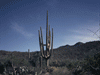
| We passed the sign for Pinnacles National Natural Monument which we planned to visit on the return. The road turns a few times and up ahead we saw massive piles of various white minerals and mining and processing equipment. The town of Trona is long and narrow, following Highway 178 as it snakes through the valley just a stones throw from Inyo County. |
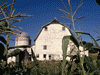
| Our first stop was the Old Guest House Museum (13193 Main Street). Hours are short and we had called ahead, so we were expected. The Guest House was once a place for long term logging for people working in the mining plants. Built about 1912, it originally had four apartments but was later remodeled to have twelve guest rooms. There are about a half dozen rooms that are now gallery spaces for historical photos, maps, and artifacts from Trona's history. Photography wasn't allowed, so take my word that there were artifacts there. We spent about an hour here and then we followed a docent to History House (83001 Panamint Street). |
| Trona is a company town and many of the houses are about the same size and shape. Later we saw several that were unoccupied, but History House (built about 1920) is being used as additional exhibit space. The house was decorated about the way it probably was when built almost a century ago. I always enjoy seeing kitchen gadgets of bygone days and trying to figure out what they did. The yard behind History House contained many artifacts of Trona's mining history including small ore cars, crushing machinery, hand tools, a safe door, and other items. |
| Adjacent to History House is the Trona Railroad Museum. The Trona Railroad, a short line railroad which began operation in 1914, connects to the long haul railroads and is responsible for most of the mineral exports from the mines of Trona. The Trona Railroad Museum is not much more than a one-room building filled with railroad related artifacts and a caboose (reported to have been built in 1958) in front, but there was enough to keep us a this site for another hour. |
| We then drove around the town for another hour. The town was quiet and looked almost deserted, but it was a week day and most of the population was probably working in the various mining facilities. While not a tourist Mecca, I enjoy seeing historic towns and buildings and there were many old buildings in Trona. The town now pushes up to the southern border of Inyo County and is a gateway to Death Valley. |
| The company town, with a population of about 2,000 - 3,000 people, was founded in 1914 by the American Trona Corporation, but the region's history goes back further. In 1862, John W. Searles and two partners discovered borax in the dry lake that later would bear his name. It was not until ten years later that he realized its value. In 1873, Searles staked a claim to 640 acres of the dry lake and formed San Bernardino Borax Mining Company. Shortly after John's death, the company was sold and then shut down. The mine reopened and had a long series of ownership until 1914 when The Trona Railway Company completed 31 miles of track to Trona from the Searles Station junction with the Southern Pacific Railroad and the town was founded the same year. Later the adjacent towns of Argus, West End, and Pioneer Point were established. Following this was yet another series of owners of the company. In 2004, Sun Capital, LLC. purchases 80.1% of the Searles Valley holdings of IMC Global and renamed the company Searles Valley Minerals, Inc., with IMC retaining the remaining 19.9%. The mine has changed hands so often, by the time you read this, it may have changed again. |
| The region is rich in minerals and mining is the main industry for the town. The town is named for the mineral trona, Hydrated Sodium Bicarbonate Carbonate. In the valley, there are deposits of soda ash, sodium sulfate and boron. The dry lake holds 99 of the 103 chemicals on the Periodic Table of Chemical Elements. Searles Lake was the only American source of potash during World War I. Minerals are pumped to the surface as a rich chemical-laden brine and piped to the processing plants for extraction of the currently most salable chemicals. |
| Keeping Trona's rich history alive is the Searles Valley Historical Society which can be reached at: |
|
Searles Valley Historical Society P. O. Box 630 13193 Main Street Trona, CA 93592-0630 Phone (760) 372-5222 |
| Once we were satisfied that we had seen the highlights of Trona, we turned back south a few miles to the turn off to Trona Pinnacles at Pinnacles National Natural Landmark. But first we stopped a few minutes at "The Fish Head Rocks" This natural rock formation, with a resemblance to fish, has been enhanced with paint to tax the viewer's imagination a bit less. |
| Trona Pinnacles, a natural wonder, are only a few miles outside of town and about 6 miles off the highway on a reasonably maintained dirt road. It takes only a turn or two before the pinnacles are visible in the distance, then several more miles to reach them. Even from a distance, the formation is fascinating and beautiful. In fact, the size is better appreciated from a distance. As we got closer, it was more difficult to see how many and how spread out they were. The pinnacles were formed long ago where underwater mineral springs reacted with the mineral saturated water of a now long dead lake. Bacteria reacted with the minerals to form these growing towers. |
| There were only two or three groups or individuals when we arrived. We drove and walked around the site, taking photos and marveling. There is what looks like one small horizontal mine shaft, or maybe some geologist wanted to know what the inside looked like. In and of itself, it was not of great interest aside from being the only apparent man-made disturbance. |
| The trails and roads spread out for some distance into this formation and we traveled several of them. Although remote and not a major destination, I felt that it was well worth the effort to visit. |
| Be forewarned, there are no facilities except a port-a-potty. There is no visitor center and just a small information kiosk. |
| We needed to get home and it was now late afternoon and would be dark soon, so we turned back to the highway. On the way back to Highway 178, we were met by many cars heading toward the Pinnacles. I speculated the Pinnacles are a great place from which to watch the sunset or these were local kids looking for a party spot. |
| We headed home the way we came and arrived home an hour or two after dark. Since most of my camera equipment had been stolen a month earlier, I hope to return someday with the replacement equipment and get better photos. It was a long day and we traveled far from Los Angeles, but I enjoyed this day of discovery and a remote corner of San Bernardino County. |

|

|

|
| Note:This is not the official site for any of the places shown in Places Earth. Places Earth is not responsible for accuracy of the information. Hours of operations, prices, exhibits, and sometimes locations are subject to change without notice. |
|
Support this Web Site I hope that you find this web site helpful. It started because of my love for Architecture and interest in History and a desire to share my photographs and tales of my adventures. I don't allow paid advertising. This web site is for your benefit and enjoyment and I make no profit on it. For twenty years it has been supported primarily from my regular paycheck as a Set Designer. If you are in the need of a designer, please see my Set Designer portfolio site Set Design Portfolio. |
|
Links |

|
This site maintained by Kenneth A. Larson. Copyright © 2004 - 2023, Kenneth A. Larson. All Rights Reserved. Website content including photographic and graphic images may not be redistributed for use on another website. |

|

|

|