Places, Earth
Three Days of the Sequoia
Three Days of the Sequoia

|
|
Places, Earth
Three Days of the Sequoia |
|
|
Day One:
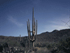
We got off about 6:30 heading north on Interstate 5 and then Highway 99. The first rest area at Lebec was closed which was OK because the sign said the next was 58 miles ahead and we thought we could hold out that long. Fifty-eight miles later we did need the rest area and this one was also closed. We managed to hold on until Visalia where we found a gas station right at the junction of Highways 63 and 198, Highway 198 leads to the southwest entrance to Sequoia National Park, the second-oldest national park. We arrived at the Ash Mountain Entrance about 10:30 and continued on to the Foothills Visitor Center where we got some info and tickets to the 3:00 tour of Crystal Cave. Tickets are not sold at the cave so visitors must obtain tickets at the Foothill or Lodgepole Visitor Centers. We had enough time to make a few quick stops, such as Tunnel Rock, a large bolder resting such that they once allowed cars to drive under. We also shot a few photos of the Kaweah River below and stopped for a picnic at Hospital Rock Picnic Area. We enjoyed our picnic beneath oak trees and followed the short trail down to the river below. By this time we were a little tight getting to Crystal Cave in time for the tour so we pressed on. The rush was slowed a little by road construction. A section of winding mountain road about three miles long was only one lane with construction, materials, and equipment covering the other lane. There was a long wait as cars traveled the single lane in the other direction. Finally we continued on our way and arrived at the cave with a half hour to spare. We were told to put our food and anything that smelled into a bear box, a sturdy metal box that bears still haven't found a way to open. Bear claws to cars are sort of like can openers. The hike down to the cave entrance wasn't too hard, the hike back up was. Our guide Alex took us though the twisting path through several large rooms and small passages. It seems Alex is an experienced recreational caver and he often pointed out back passages only for the experienced. Crystal Cave is a marble cave, somewhat rare in the cave world. In one spot where a stream flowed, the bed looked like a marble floor. There were the usual formations of stalagmites and stalactites, columns, draperies, flowstone, and more. The path through the cave is a loop and all too soon we were back in the first room where we had previously stopped and then headed out. We reached the parking lot about the same time as most of the people for the 3:30 tour did. Although at high elevations, Sequoia National Park is still in Southern California and does get hot and it was a warm hike back to the parking lot. Before heading back through the construction area, we stopped briefly at Lodgepole Visitor Center which is closer to the big trees and most of the other main points of interest. We got a better idea of our plans for tomorrow and then did head back to Three Rivers where we had reservations. The delay at the construction didn't take as long this time and about an hour later we were checking into the motel. We unloaded, had a picnic dinner in our room, and fell off to a well deserved sleep. Day Two We awoke early to the Sierra silence, got ready, ate, and headed into town. We photographed a few deer in Three Rivers, attended Mass at a nice little church, and returned to the park. Our receipt from yesterday allowed reentry to the park for 7 days and we headed back in. We stopped at Hospital Rock Picnic Area again because somehow we missed Hospital Rock yesterday. It is a rock covered on one side with early Patwisha art and was later involved with an Anglo's recovery from an injury, thus the name. I was later told that it may be a piece of Moro Rock that broke off and slid down the hill. A few steps to the right are mortar holes from grinding acorns. We learned that there are several things to see around the Hospital Rock Picnic Area. We braved the road work and headed back toward the Giant Forest area. Our plan was to park at the Museum and take the shuttle to Moro Rock and the General Sherman tree, but by the time we arrived about 11:30, the parking lot was full. So we continued a few miles and parked at the General Sherman Tree parking area. This actually worked better because it was all down hill to the Accessible Parking shuttle stop. The General Sherman Tree is believed to be the most massive living thing on earth by volume, although not the tallest or oldest. These Sequoia trees are massive. Visitors begin at the parking area and walk down a short distance to an overlook to the giant tree down the hill, then walk to the base. At 275 feet tall and about 25 feet in diameter, this 2,3000 to 2,700 year old tree is awe inspiring. Once we admired this huge piece of foliage, we continued downhill to the shuttle stop. The shuttles are great in that you can park once and get everywhere, they ease congestion, and are better for the environment, but accompanied by long waits, often in the sun. We shuttled down to the Museum then stood in line to take another shuttle to Moro Rock. Mono Rock is a large granite dome (like Half Dome at Yosemite) that stands isolated and allows a great view from the top. To make climbing easier, an often narrow quarter mile path has been cut into the rock including about 400 steps to an observation platform on top of this giant rock, 6,725 feet above sea level. My wife wasn't sure about climbing the rock so she told me to go ahead and she would try and go back to the museum if she got tired of waiting. It wasn't a hard climb and I reached the top faster than I had expected and enjoyed that magnificent view. I was able to look down at most of the three miles of road work and out into the smog over the San Joaquin Valley. On the other side is the divide between the San Joaquin River watershed and the dry basin east of the Sierra Nevada Range. When I reached the bottom of the steps, my wife was already in line to shuttle back to the museum. The Giant Forest Museum is not large but new and had several well presented exhibits on the Sequoia tree and its environment. A math game reads a cone holds 200 seeds and there are 91,000 seeds per pound, how many cones are required to make a pound (455)? A spinning wheel demonstrates the small chance that an individual seed has of become a full size tree as most stops of the wheel result in the seed or tree not making it, but only one stop represented maturity. We learned that we don't know how long a Sequoia trees can live (thousands of years) and that most mature trees die when they fall over. Also that fire is essential to the life cycle of the tree and until recently, fires were suppressed. There are only a few stands of these trees along this part of the Sierra Nevada Range and no where else on earth. We stopped to look at Sentinel Tree and waited in another line to shuttle back to the car. It was about 4 pm when we headed back to Three Rivers where we took a few photos of points of interest such as Paul Bunyan and the Three Rivers Historical Museum, the historic Pumpkin Hallow Bridge (built 1922), a piece of an old Edison power plant, and a large cow building. We enjoyed dinner in our room and got some needed rest. Day Three We awoke about five again and got ready and packed. After breakfast we checked out and were on our way back to the park one last time. First we stopped to photograph a few more points of interest in and around Three Rivers such as the Kaweah Post Office, a quant and friendly little post office built in 1910. We entered the park one last time and used the facilities at Hospital Rock before waiting at the road work stop. I said something to the maintenance man and he pointed out the graffiti on the restroom walls that he only painted the day before. Some people don't care. We stopped for a few minutes at the Museum for a last souvenir and more photos and we headed north toward Kings Canyon National Park. Kings Canyon and Sequoia National Parks are adjacent and managed as one park but with no road directly connecting them. We drove though parts of Sequoia National Forest (some of which has National Monument status) to reach the two disjointed sections of Kings Canyon National Park, part of which was once General Grant National Park (established 1890) but was absorbed into Kings Canyon in 1940. The Grant Grove section protects the General Grant Tree and several stands of Sequoia trees, including the largest stand. We stopped at the Grant Grove Visitor Center and then pressed east deep into the park, the first half of the drive through the National Forest. It took about an hour and a half to reach the "End of the Road" where there is a camp site amide towering trees and cliffs. We stopped to read an information sign quoting John Muir as describing Kings Canyon as even grander than Yosemite, not far to the north. Both valleys were glacier carved but Kings seems much narrower and this time of year at least (late summer) I saw no waterfalls although the Kings River runs through the canyon. On our return, and back out of the park and into Sequoia National Monument again, we stopped at Boyden Cavern. Long ago I had heard that there was another cave with public tours in the area but could find no information on it. Even though we were a little behind schedule, we stopped for this unplanned cave adventure. Tours are about an hour on the hour until 5 (summer hours). On the way into the park we had just missed one tour so we paced ourselves to be back in a bit less than two hours for another tour on our way out. Unlike the hike to Crystal Cave two days before which was easy down but long and steep on the way back up, the hike to Boyden was short but steep going but easer coming back. Like Crystal Cave, Boyden is a marble cave with many similar beautiful formations such as the wedding cake, a stack of pancakes, and the Christmas Tree. Also like Crystal Cave, the temperature inside was about the mid 50s while hot outside. When we reached the end of the cave, our guide pointed out some tree roots and told us we had walked about 750 feet through the mountain and were only about twenty feet from the other side. There is another adjacent larger cave (Church) with occasional tours for more experienced cavers. There are several options for other cave adventures starting here. We were given two options for leaving the cave, one on our own back along the path or a more challenging lower route with the guide. We chose the former. We were now way behind schedule and hurried back, stopping about 25 minutes at General Grant Tree, often called "The Nation's Christmas Tree," the third largest tree known on Earth (back in the Grant Grove section of Kings Canyon National Park). Now we headed home with as little delay as possible through Fresno and the San Joaquin Valley arriving home about 9:30. We had been planning this trip for years and canceled it the two previous years. I'm glad we went, my wife wasn't sure but seemed satisfied in the end. We did the highlights but are not likely to return. Crystal Cave was the first cave I toured in the early 60s and is beautiful, but I've seen better and they were easier to reach. Boyden was a little easier to hike to, but more isolated. I survived Moro Rock and witnessed a spectacular view and we saw several giant Sequoia trees and were awed by their majesty. If you can, you should see these immense trees. |

|

|

|
| Note:This is not the official site for any of the places shown in Places Earth. Places Earth is not responsible for accuracy of the information. Hours of operations, prices, exhibits, and sometimes locations are subject to change without notice. |
|
Support this Web Site I hope that you find this web site helpful. It started because of my love for Architecture and interest in History and a desire to share my photographs and tales of my adventures. I don't allow paid advertising. This web site is for your benefit and enjoyment and I make no profit on it. For twenty years it has been supported primarily from my regular paycheck as a Set Designer. If you are in the need of a designer, please see my Set Designer portfolio site Set Design Portfolio. |
|
Links |

|
This site maintained by Kenneth A. Larson. Copyright © 2004 - 2023, Kenneth A. Larson. All Rights Reserved. Website content including photographic and graphic images may not be redistributed for use on another website. |

|

|

|