Places, Earth
San Diego, 2006
San Diego, 2006
|
|
Places, Earth
San Diego, 2006 |
|
| In May of 2006, we embarked on another of our annual visits to San Diego where my best friend now lives. We had planned to leave early, but didn't get out the door until after 7. We drove south on the San Diego Freeway (I-405) which isn't too congested early Saturday morning. At Oceanside, we turned east onto Highway 76. Within minutes, we sighted our first stop, Mission San Luis Rey. |
| Founded in1778 by Padre Fermin Francisco de Lasuén, Mission San Luis Rey de Francia was the 18th mission founded in a chain of Spanish missions in Alta California. San Luis Rey is often referred to as the King of the Missions because it was at one time the largest building in California. Among the highlights are (believed) the first pepper tree in California (within sight, but well away from the public) and the lavendaria. It was still early and the mission would not open for another half hour, so we wandered the cemetery, lavendaria, and other accessible areas and moved on. |
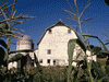
| Mission San Luis Rey de Francia had two assistencias, or extension missions, Las Flores and San Antonio de Pala. Las Flores is not restored and difficult to visit, but Mission Pala has been in continuous operation for nearly 200 years and is still a vital and active core to the community of the Pala Reservation. It took about a half hour to reach Pala, continuing east on Highway 76, a little east of Highway 15. This was my third visit to the "forgotten mission" as Pala is sometimes called. While Pala never developed into a full mission, it currently is a more interesting visit than many of the better know 21 coastal missions. The church is small, but noted for the Indian artwork on the walls. The garden within the quadrangle is peaceful and the detached bell tower is believed to be unique in the mission system (although copied by the restorers of another assistencia). It was still somewhat early and we had a lot planned, so we continued east to our third stop. |
| San Luis Rey was not the only mission with an assisencia. It took us about a half hour to reach Santa Ysabel, assistencia to Mission San Diego, believed founded 1818. I had been here before, but wanted to see something I missed the previous time. That time, the place was deserted. This time, the funeral of a local, and obviously very popular, community member was in progress and there were cars and people everywhere. Today, the site contains a few floor tiles of the original church, a new small church with a small museum, and a cemetery. The entire site was a parking lot so I checked our my objective and moved on. Santa Ysabel is on Highway 79 about ten minutes north of the tourist town of Julian. |
| Julian is a popular tourist town which escaped a major wild fire a few years earlier. Famous for its pie shop, antique shops, and other tourist attractions, we unfortunately didn't have time to linger this time, so we made a quick stop and continued south. |
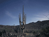
| South of town, the aftermath of the recent fire was evident. Many hills were covered with burned out tree trunks and new growth. We stopped at Desert View Park, a turn off that overlooks Anza Borrego Desert State Park. Desert View Park was also surrounded by the charred brush from the fire. Highway 79 continued through Cuyamaca Rancho State Park, a popular hiking and camping area including a nice lake. We traveled Highway 79 for a bit over an hour before reaching Highway 8 and turning west toward San Diego. |
| We arrived at my friend's home in Alpine, but he had an errand to run so he gave me directions for my next stop and we proceeded without him. We drove back east on Highway 80 for about twenty minutes and exited at Sunrise Highway. We then drove Old Highway 80 almost to the Imperial County line. This was typical of an old highway, once well traveled, but now known mostly to the locals. We paused at the Amos Buckman's house and water bottling plant. The pumping of ground water for agriculture caused the water level to drop and the bottling plant closed. We passed a picturesque windmill and not so picturesque place where old trucks, trailers, and campers go when they die. At one point, the road overlooks the border with Mexico and the Mexican landscape rolled out to the south. |
| We turned around at the town of Jacumba. Once a prosperous little town, Jacumba has fallen off dramatically with the new Highway 8 and traffic bypassing the town and loss of railroad traffic. The railroad station is no longer in use but there is a collection of old battered railroad cars that I'm sure a museum somewhere would love to restore. Just off the main drag was what looked like a one-time nice hotel, now just crumbling walls. Time and progress marches forward, but it's sad to see what is often left behind. It was time to met my friend, so we returned to Alpine, this time most of the way on the new Highway 8. |
| Alpine is a nice little town, close enough to San Diego to be a suburb, yet far enough to be in its own world. A little upscale, it still retains some small town charm. My friend took us to a local restaurant and we returned to his place to marvel at all his recent projects. I don't drive well at night so we headed off in early evening for our accommodations in San Diego, a half hour west. |
| We got up early Sunday morning and left for mass at Mission San Diego de Alcala, the first mission founded in what is now California. Father Junipero Serra founded this mission in 1769 on what is now named Presidio Hill, near Old Town. It was later moved to its current location to remove itself from military interference, then returned to the hill for safety, then back to its present location. We wandered through the small garden/cemetery and the museum, then stopped to check the progress of the on-going, but slow-going archeological excavation just across from the gift shop. |
| Mission San Diego got it's water from a dam a few miles upstream. We had tried to explore this site, now in Mission Trails Regional Park, a few years earlier, but large brush fires had devastated much of San Diego County that year, and most of the park was closed. This time, all was well, the plants had recovered, and hikers were everywhere. A small parking lot lies between the dam and the park road, making access easy. The stone dam has a breach or two today allowing water to flow through the dam unhindered. Still it is quite obvious that this was once a large construction and must have provided ample supplies of water to the mission. We stayed about an hour and a half, walking several trails that had been closed the time before, then moved on. |
| I was almost past the next stop before I suddenly remembered, so I quickly pulled off the freeway (sorry sir) and drove up Presidio Hill to the Serra Museum and Presidio site. I had visited the Presidio before, but somehow missed that the wall traces out the square of what is believed to be the original site. There are several sculptures commemorating the Indians and the missionaries. A few steps away is the Serra Museum dedicated to the mission as well as other changing exhibits of local interest. This time, there was an exhibit to the Serra Museum itself. Most of the exhibit on the Museum was in the tower. Since many people congregated in the small tower to see this exhibit, it was a bit crowed but well worth the effort. I was not allowed to take photographs, so was disappointed. |
| We left Presidio Hill and headed south out of the City of San Diego and then some minutes later, back into the city. A quick look at the map shows that San Diego expanded its borders south past other cities by annexing a swath of the bay allowing it to extend the city limits almost to the Mexican border. It wasn't hard to find our next destination, but wasn't easy to reach. |
| While there are great hopes for Border Field State Park, most describe it as one of the worst parks in the country. The Tijuana river flows northwest out of Mexico toward the Tijuana Estuary in the US. This river often floods and usually caries pollution and raw sewage. The road was closed and I was not allow to drive my car, so I had to walk two miles each way, tip-toeing around the pollution, to the monuments. There was clear signs of construction intended to improve the park and I was told they are trying to fill the low spot of the road so it is passable all year, but it's taking time. I walked a long way west, then a long way south, then a long way west again. Finally I made another turn to the left and started up a hill. For most of this walk, I was surrounded by wild flowers and observed the occasional rabbit, and the Mexican Bull Ring By the Sea was almost always visible and my guiding star. As I finally neared the border, Mexicans on the other side of the border fence started joking with me, since I was the only person in the park besides the Border Patrol. |
| I finally reached the top of the hill and there was the monument to friendship between the US and Mexico. A modest monolith is surrounded by a great round concrete disk. While obviously once intended to allow a walk around the monolith, the fence runs up to it on both sides with no way now to circle the tower. A group of men stood on the other side of the fence mugging for my camera, so I went over and visited with the Border Patrol for several minutes until the men moved on and I was able to photograph the monument. The Border Patrol informed me of the fence leading out into the sea about 100 feet, but with missing pieces, the work planned for the park to improve it, the polluted water I carefully walked around - and suggested that I wash my shoes before getting back in the car. I looked out over a beautiful beach, devoid of people and thought of the people crowed on similar beaches a few miles north but easier to get to. It had now taken me much longer to visit this site than I had intended, and my wife had been waiting in the car all this time, so I hurried back the way I came. Joy was well rested but anxious for me to come back, so we went on. |
| Before heading back to San Diego, we stopped at the Tijuana Estuary Visitor Center which overlooks Tijuana River National Estuarine Research Reserve which occupies the area between Imperial Beach and the border. We didn't have time to explore this vast natural area where the Tijuana River meets the Pacific Ocean. Trails extended some distance into the estuary and new construction hinted of an expanded Visitor Center. |
| We had hoped to see the Maritime Museum since the Russian submarine wasn't ready for viewing the year before, but this late in the afternoon, parking was almost impossible. We decided that we would try Old Town, something we had dropped from our plans earlier, and if there was no parking, we would go straight home. Fortunately, almost by magic, a parking space opened just as we pulled in. We didn't stay long, it was late, but there had been some changes from the year before, and I wanted to see them. There are many historic buildings in the site and many stores. I always notice something I hadn't noticed before as we walked paths we had bypassed on previous visits. A year earlier, Bazaar Del Mundo gave way to Plaza Del Pasado while a new small shopping area a few blocks away has assumed the Bazaar Del Mundo name. Many people feared that this change would degrade Old Town, but it looked about the same to me in a quick walk through. It was now time to finally head north and home. We arrived a bit before dark and started making plans for our next trip which we had hoped to make soon and see the Aircraft Carrier Museum and Maritime Museum which we missed this time, but as you will read in the next installment, it didn't happed for a long time. |

|

|

|
| Note:This is not the official site for any of the places shown in Places Earth. Places Earth is not responsible for accuracy of the information. Hours of operations, prices, exhibits, and sometimes locations are subject to change without notice. |
|
Support this Web Site I hope that you find this web site helpful. It started because of my love for Architecture and interest in History and a desire to share my photographs and tales of my adventures. I don't allow paid advertising. This web site is for your benefit and enjoyment and I make no profit on it. For twenty years it has been supported primarily from my regular paycheck as a Set Designer. If you are in the need of a designer, please see my Set Designer portfolio site Set Design Portfolio. |
|
Links |

|
This site maintained by Kenneth A. Larson. Copyright © 2004 - 2023, Kenneth A. Larson. All Rights Reserved. Website content including photographic and graphic images may not be redistributed for use on another website. |

|

|

|